ROAD AND TRANSPORT IN INDIA
- India has one of the second largest road networksin the world with a total length of 63.73 lakh km.
- After Independence, a twenty-year road plan (1961) was introduced to improve the conditions of roads.
- For the purpose of construction and maintenance, roads are classified as National Highways (NH), State Highways (SH), Major District Roads and Rural Roads.
- About 85 percent of passenger and 70 percent of freight traffic are carried by roads every year.
- Sher Shah Suri built the Shahi (Royal) road to strengthen and consolidate his empire from the Indus Valley to the Sonar Valley in Bengal.
- This road was renamed the Grand Trunk (GT) road during the British period, connecting Calcutta and Peshawar. At present, it extends from Amritsar to Kolkata.
- National Highways
- The main roads which are constructed and maintained by the Central Government.
- Meant for inter-state transport and movement of defence men and material in strategic areas and also connect the state capitals.
- The length of the National Highways is about 1,44,634 kms.
- The National Highways constitute only about 2 percent of the total road length but carry 40 per cent of the road traffic.
- National Highways Development Projects :- NHAI has taken up some major projects in the country under different phases.
National Highways Authority of India
- It is an autonomous body under the Ministry of Road Transport and Highways, operationalized in 1995.
- It is entrusted with the responsibility of development, maintenance and operation of National Highways.
- This is also the apex body to improve the quality of the roads designated as National Highways.
| Golden Quadrilateral | It comprises construction of 5,846-km long 4/6 lane, high density traffic corridor, to connect India’s four big metro cities of Delhi-Mumbai-Chennai-Kolkata.With the construction of Golden Quadrilateral, the time, distance and cost of movement among the mega cities of India will be considerably minimised. |
| North-South and East-West Corridors | North-South corridor aims at connecting Srinagar in Jammu and Kashmir with Kanyakumari in Tamil Nadu (including Kochi-Salem Spur) with 4,076-km long road.The East-West Corridor has been planned to connect Silchar in Assam with the port town of Porbandar in Gujarat with 3,640-km of road length |
- State Highways
- They are constructed and maintained by the state governments.
- They connect the state capitals to district headquarters and other important towns.
- These roads are connected to National Highways.
- They constitute 4 percent of the total road length of the country.
- District Road
- These roads are the connecting link between the district headquarters and other important places in the district.
- They constitute 14 percent of the total road length of the country.
- Rural Road
- These roads are important for connecting rural areas.
- About 80 percent of the total road length in India
- These are classified as rural roads.
- There are regional variations in the density of rural roads as they are influenced by the nature of the terrain.
- Border Roads Organisation(BRO)
- Established in 1960 to strengthen defence preparedness through improvement of strategically important roads along the Northern and North-Eastern borders.
- Premier multi-purpose construction agency.
- It comes under the Ministry of Defence.
- Bharatmala
Bharatmala is a proposed umbrella scheme for:
- Development of State roads in coastal border areas including connectivity to nonmajor ports.
- Religious and Tourist Places Connectivity Programme in Backward Areas.
- Setu Bharatam Project, which is for construction of about 1500 major bridges and 200Rail Over Bridges, Rail Under Bridges.
- District Headquarters Connectivity Scheme for development of about 9000 km of newly declared National Highways. This programme was targeted to be completed by 2022.
Rail transport in India
- Indian Railway network is one of the longest networks in the world which facilitates movement of both goods and passengers.
- The first train in India was started by Lord Dalhousie on 16th April, 1853 from Bombay to Thane (34 km).
- Slogan of Indian Railway: “Lifeline of the Nation”.
- Longest Railway route in India: 4273 km from Dibrugarh (Assam) to Kanyakumari (Vivek Express train).
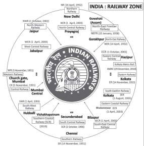
- Indian Railways is the largest government undertaking in the country.
- Indian Railways is divided into 18 zones: Northern Railway (largest), North Eastern Railway, North Eastern Frontier Railway (smallest), Eastern Railway, South Eastern Railway, etc
- Northernmost railway station: Baramulla in Jammu and Kashmir.
- Westernmost railway station: Naliya near Bhuj in Gujarat.
- Southernmost railway station: Kanyakumari.
- Easternmost railway station: Ledo on the branch line from Tinsukia.
| Depending on the track width | |
| Broad Gauge | The distance between broad gauge lines is 1.676 meters.In March 2016, the total length of broad gauge lines was 60510 km. |
| Meter Gauge | The distance between the tracks is one meterIn March 2016, its total length was 3880 km. |
| Narrow gauge | In these cases the distance between the tracks is 0.762 m or 0.610 m.The total length of narrow gauge was 2297 km in March 2016It is generally restricted to hilly areas. |
Two UNESCO World Heritage Sites of Indian Railway
- Chhatrapati Shivaji Maharaj Terminal, Mumbai and Mountain Railways of India:
- Darjeeling Himalayan Railway, Nilgiri Mountain Railway, Kalka-Shimla Railway.
Water Resources in India
- It is a fuel-efficient and environment-friendly mode of transport.
- Inland waterways
- India has 14,500 km of navigable waterways, contributing about 1% of the country’s transportation. It includes rivers, canals, backwaters, creeks, etc.
- At present, 5,685 km of major rivers are navigable by mechanised flat bottom vessels.
- The Inland Waterways Authority was set up in 1986 for the development, maintenance and regulation of national waterways in the country.
- The backwaters (Kayal) of Kerala have special importance in inland waterways.
- Apart from providing cheap means of transport, they are also attracting a large number of tourists to Kerala.
| Waterways | Stretch |
| NW-1 | Allahabad-Haldia section (1,620 Km.) |
| NW-2 | Sadiya-Dhubri section (891 Km.) |
| NW-3 | Kottapuram-Kollam section. |
| NW-4 | Specified sections of Godavari and Krishna rivers along with Kakinada Puducherry Canals (1078 Km.) |
| NW-5 | Specified sections of Brahmani River along with Delta Channels of Matai River, Mahanadi and Brahmani Rivers and East Coast Canals (588 Km.) |
| NW-6 | Lakhimpur to Bhanga on Barak River (121 Km.) |
- Oceanic Routes
- India has a vast coastline of approximately 7,517 km, including islands.
- Thirteen major and 200 minor ports provide infrastructural support to these routes.
- Approximately 95 per cent of India’s foreign trade by volume and 70 per cent by value moves through ocean routes.
- Maharashtra (53) has the most ports in India, followed by Gujarat (40), Tamil Nadu (15) and Karnataka (10).
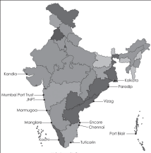
Major Ports in India
| Bay of Bengal | |
| Andaman and Nicobar Islands | Port BlairThe port is connected to mainland India through ship and flight.This port is located between two international shipping lines namely Saudi Arabia and US Singapore. |
| Eastern Coast | |
| West Bengal | KolkataIndia’s only major riverine port.Located on the Hooghly River known as Diamond Harbor |
| Odisha | ParadipThe natural harbour is related to the export of iron and aluminium |
| Andhra Pradesh | VisakhapatnamIndia’s deepest port is related to the export of iron ore to Japan. Facilities for building and fixing ships are available |
| Tamil Nadu | ChennaiArtificial harbour.Second busiest Chandargah.EnnoreIndia’s first corporatised port.TuticorinA major port in South India dealing with fertilizers and petrochemical products. |
| Western Coast | |
| Gujarat | KandlaKnown as Tidal Port.Approved as Trade Free Zone.Largest port by volume of cargo handled. |
| Maharashtra | Mumbai port trustLargest natural harbour in IndiaBusiest port in India. Jawaharlal Nehru Port TrustNhava Sheva, also known as Navi Mumbai.Largest artificial harbour.It is the largest container port in India. |
| Goa | MormugaoSituated at the mouth of the Zuari River. |
| Karnataka | MangaloreTrades in iron ore |
| Kerala | KochiLocated in Vembanad lakeExport of spices and salt. |
Air Transport
- Air transport in India began in 1911 when air mail operations began between Allahabad and Naini, a short distance of 10 km.
- The Airports Authority of India is responsible for providing safe, efficient air traffic and aeronautical communication services in the Indian airspace. The authority manages about 125 airports.
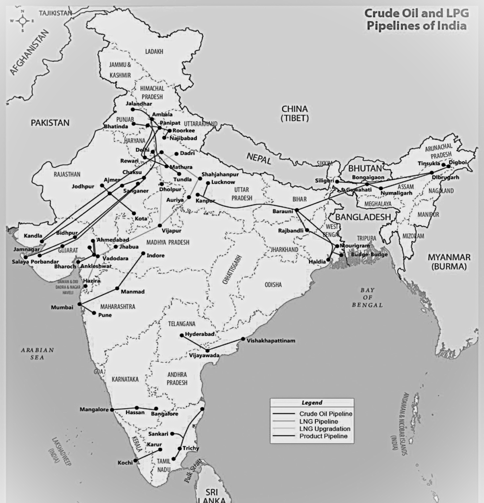
Oil and gas pipelines
- Pipelines are the most convenient and efficient means of transporting liquids and gases over long distances.
- Even solids can be transported by pipelines after being converted into slurry.
- Oil India Limited (OIL) is engaged in the exploration, production and transportation of crude oil and natural gas under the administrative structure of the Ministry of Petroleum and Natural Gas. It was incorporated as a company in 1959.
- Asia’s first cross country pipeline covering a distance of 1,157 km was constructed by OIL from Naharkatia oil field in Assam to Barauni Refinery in Bihar.
- In 1966 it was further extended to Kanpur.
- Another extensive network of pipelines has been built in the western region of India of which Ankleshwar-Koyali, Mumbai High-Koyalia and Hazira Vijaypur-Jagdishpur (HVJ) are the most important.
- Recently a 1256 km long pipeline connecting Salaya (Gujarat) to Mathura (UP) has been constructed. It supplies crude oil from Gujarat to Punjab (Jalandhar) via Mathura.
- OIL is in the process of constructing a 660 km long pipeline from Numaligarh to Siliguri.