
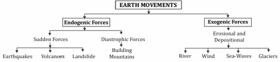
Endogenous forces
- The forces originating in the interior of the earth are called endogenous forces. Endogenous forces (crust deforming forces, volcanic activity, earthquakes, etc.) create unevenness on the surface of the earth while exogenous forces (flowing water, sea waves, glaciers, underground water, wind, etc.) are plane establishing forces
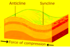
- Two types of forces work in horizontal movement- compression force and tension force.
- The force produced by compression causes the layers of rocks to bend, as a result of which the raised part is called anticline and the sunken part is called syncline.
- Anticlines – The raised part of the rocks due to folding is known as anticline.
- Synclines – The sunken part of the rocks due to folding is known as syncline.
- Anticlinorium – When many small anticlines and synclines are formed under a large anticline, then that shape is known as anticline. This shape is visible in folded mountain areas.
- Synclinorium – When many small synclines and anticlines are formed inside a large syncline due to unequal compression, then that particular syncline is called an isclinorium. Its shape also becomes like a fan-shaped fold.
Folds
- The process of bending of layers of rocks due to compression forces working horizontally on a common plane is called folding.
Types of folds
1. Symmetrical Fold – In this, the inclination of both the arms of the fold is the same. It is also called simple fold. When the intensity of pressure force is low and the same in both directions, then this type of fold is formed. For example – Jura Mountains of Switzerland. It is an open fold.
2. Asymmetrical Fold – In this, the length and slope of both the arms of the fold are unequal. The arm with less inclination is relatively longer and the arm with more inclination is shorter – South Pennine Mountains of Britain.
3. Monoclinal Fold – In this, one arm of the fold is absolutely vertical and the other is perpendicular to the horizontal plane. For example – Great Dividing Range of Australia.
4. Over Fold – In this, one side of the fold is not completely vertical but is slightly extended forward and forms a steep slope, while the other side, which is relatively longer, forms a slow slope due to being less inclined.
5. Isoclinal Fold – In isoclinic folds, both the sides of the fold are parallel to each other but not in the horizontal direction. In this fold, the front part appears to be hanging.
6. Recumbent Fold – In this, both the sides of the fold are parallel to each other and in the horizontal direction. It is also called double fold.
7. Overthrust or Overturned Fold – These are folds with inclined axial planes in which both the limbs are dipping essentially in the same general direction. The amount of dip of the two limbs may or may not be the same. Over folding indicates very severe degree of folding.
8. Fan Fold – Due to difference in compression at different places, sometimes many small anticlines and synclines are found in a large anticline. Such a shape is called isoclinal.
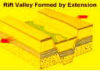
Fault
- Faults include cracks, fractures and ruptures. Faults are formed by both the forces of horizontal movement (compression and tension forces), but tension forces are more important. Most of the faults are formed due to this.Major landforms created by faulting
1. Rift Valley
- It is formed when the rock columns between two fault lines sink downwards. When two land masses slide in opposite directions due to tension-induced forces, this type of landform is formed.
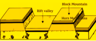
2. Ramp Valley
- It is formed when the pillar between two fault lines remains as it is but due to compressional force both the pillars on the sides rise up. Brahmaputra valley of Assam is a prime example of ramp valley.When the pillar between two faults remains as it is and the pillars on the sides sink down, then a block mountain is formed. Satpura mountain of India, Black Forest and Vosges Mountain of Germany, Wasatch range and Sierra Nevada of United States of America and Salt Range of Pakistan are prime examples of block mountains
Exogenous forces
- The main action of exogenous force on the earth’s surface is denudation. This includes the combined action of weathering and erosion. Weathering is a static action while erosion is a dynamic action.
WEATHERING
- It is defined as mechanical disintegration and chemical decomposition of rocks through the actions of various elements.
- There is no motion of materials taking place so it is in-situ or on site process.
- Factors influencing the weathering & depth:Geological Structure; Climate; Topography; Natural Vegetation.
Type of Weathering
- Physical: Due to thermal changes, frost action and hydraulic action (repeated wetting and drying).
- Chemical: Dissolving action of water and various organic chemicals, oxidation, and carbonation etc.
- Biological: Burrowing and wedging by organisms like earthworm and termites.
Significance of Weathering
- Responsible for the formation of soils and erosion and deposition.
- Biodiversity is basically depending on the depth of weathering.
- Weathering of rocks and deposition helps in the enrichment and concentrations of certain valuable ores.
Erosion
- The transfer of weathered material to another place is called erosion.
- Erosional geomorphic agents:-
- Controlled by climate: Wind, running water, and glaciers
- Depending on the Location: Waves.
- Lithological Characteristics of region: Ground water.
- Factors Influencing Erosion :- Rock structures such as fold , fault, joints, fractures, hardness, softness, permeability and impermeability , Stability of sea level, Tectonic stability of landmass ,Climate.
- The main processes under erosion are as follows:-
1. Abrasion: When a process moves forward carrying with it materials like stones, pebbles, sand etc., then the erosion of rocks coming in contact with these materials by friction is called abrasion.
2. Attrition: The process of colliding with each other and getting smaller of the materials flowing with a process is called attrition.
3. Corrosion: The dissolving of soluble rocks like dolomite, limestone etc. and getting separated from the rock by water action is called corrosion.
4. Hydraulic Action: When the rock breaks and gets separated due to the high speed of water, then it is called hydraulic action. This happens through sea waves and river.
5. Water Pressure: When erosion takes place in a rock due to the pressure of water, then it is called hydraulic action. This is mainly caused by ocean waves.
6. Plucking: This is caused by glaciers. Glaciers moves forward by breaking the rocks in its path. This process is called plucking.
- Deflation: This is the process of sediments flying in dry or semi-arid regions by wind.
| Exogenous forces causing changes on the surface and the landforms produced | |||
| DynamicForces | Activities | Erosional Landform | DepositionalLandforms |
| 1. Flowing water or River | Abrasion, dissolution, friction, water Movement | V shaped ghat, I shaped valley (gorge and canyon), waterfall and rapids, river meander or meander, structural steps, river terrace, peneplain | Alluvial fan, alluvial cone, natural levee, flood plain, delta |
| 2. Glacier or Iceberg | Abrasion | U-shaped valley, hanging or suspended valley, cirque or glacier, cirque lake or tarn, arete or sharp ridge, horn or mountain ridge, nunatak, horn and tail, sheepback rock or roshmutone, icefall, fiord | Moraines, Drumlins, Esker Kames, Kame Terraces, Ketils and Hummocks, Glacial Lakes |
| 3. Wind | Runoff, abrasion, Attrition | Drainage basin or wind trough, inselberg, umbrella rock or mushroom rock, isthmus or demoiselle, zeujen, yardang, drycanter, lattice rock, wind Bridge | Sand dune, Barkhan, Nebkha, Lunettes, Tara Stupa, Whaleback Stupa Sand free corridor or Gasi, Loess, Bajada, Playa |
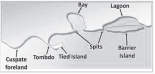
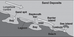
| 4. Sea water | Water movement, abrasion action, friction action, dissolution action, water pressure action | Coastal cliff, notch or tooth, coastal cave, natural chimney or wind vent, creek or gneiss, natural arch, chimney rock, cape, wave abrasion altar, stack | Beach cape, bar, offshore bar, coastal bar, spit or tongue, loop bar, connecting bar, ring bar, tombolo, bar island |
| 5. Ground Water | Dissolution, hydraulic action, abrasion, Attrition | Solution hole, solution hole, doline, polje, yuvala lapis, caverns, natural bridge, sunken creek, blind valley, karst or solution valley | Stalactite, stalagmite, cavernous pillar, drip stone, speleothem, globulite, halactite, halagmite |
Landform Development: Erosion, Transportation and Deposition
- Small to medium tracts or parcels of the earth surface are called landforms and several landforms together are called landscape.
- Each landform undergoes three stages called youth, mature and old stages.
- Various geomorphic agents bring changes to landform by erosion and deposition.
- Geomorphology is the science of landforms.
- In humid regions where rainfall is heavy, running water is the dominant agent of erosion.
- Erosion :- Upper course/youthful stage.
- Deposition :- Lower course/old stage.
Erosional and Depositional Landform of Running Water
| Erosional Landforms | Depositional Landforms |
| River Terrace :-They may consist of stream deposits. They are formed due to vertical erosion.If they are at the same level, they are called paired terraces. Reasons for the formation of river terraces:Receding water after a peak flow. Tectonic uplift of land. Sea level changes | Alluvial Plain :-Made of alluvial soils and are divided into two types Khadar and Bangar Khadar: Soils are found near the river Bangar: Soils are found away from the river They are very fertile |
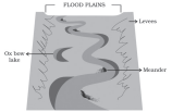
| Meanders:Loop-like channels are called meanders. Lateral erosion is common in the lower course of the rivers. Due to low kinetic energy water changes its course. When meanders are found in deep and hard rocky areas, they are called incised or entrenched meanders. Some meanders develop loops which later on are converted into ox-bow lakes.Reasons for the formation of meanders:Gentle gradientCoriolis force Irregularities along the river banks. | Alluvial Fans :-Cone shaped deposits found near the foothills.The river breaks into a number of channels.Channels shift their position in the plains.Cones have gentle slopes in humid areas and dry areas have steep slopes. |
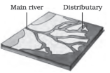
| Potholes :-Circular depressions formed by abrasion. Pebbles and boulders get collected in these holes and rotated and make depression wider and deeper. | Deltas :-Found nearby the mouth of the river and made of fine alluvial soils. They are in triangular shape. Divided by distributaries of the river. Deposited material is stratified on the basis of size ; Coarse material is deposited first and then fine material. |
| Plunge Pools :-At the foot of the water falls potholes become plunge pools [due to soft rocks]. | Natural Levees :-Low linear, parallel ridges made of coarse material found along the river bank. |
| Gorge :-Steep sides with equal width of top and bottom and small in length. They are found in semi-arid land [e.g. Brahmaputra gorge] | Point Bars:They are also called meander bars found along the convex side of meanders. |
| Canyon :-Step like slides with wider top and narrow at bottom and longer in length Found in dry areas [e.g. Grand Canyon] | Braided Channel :-Selective deposition of coarser materials causes formation of a central bar, which diverts the flow towards the banks; and this flow increases lateral erosion on the banks. As the valley widens, the water column is reduced and more and more materials are deposited as islands and lateral bars, developing a number of separate channels of water flow. |

6 TOPOGRAPHY
- Any limestone or dolomitic region showing typical landforms produced by the action of groundwater through the processes of solution and deposition is called Karst topography
Erosional Landforms of Karst Topography
- Swallow Holes :- Small to medium sized, round to sub round form.
- Doline :- Collapse sinks
- Sinkholes and flow underground streams & re-emerge at a distance downstream through a cave opening.
- Valley sinks/ Uvalas :- When sinkholes and do lines join because of the slumping of the material.
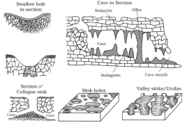
Depositional Landforms of Karst Topography
- The chief chemical in limestone (calcium carbonate), which is easily soluble in carbonated water (carbon dioxide absorbed rainwater).
- The stalagmite and stalactites eventually fuse to give rise to columns and pillars.
| Stalagmite | Stalactites |
| Formed due to evaporation of water | Formed due to condensation of Water |
| Grow from the floor and are pillar shaped. | Grow from the roof and are conical in shape. |
| Broad base and broad Edge | Narrow base and sharp edge. |
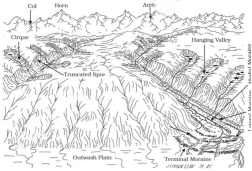
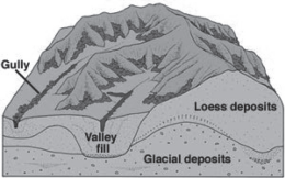
- Masses of ice moving as sheets over the land or as linear flows down the slopes of mountains in broad trough-like valleys are called glaciers.
Erosional and Depositional Landform of glacier
- The unconsolidated coarse and fine debris dropped by the melting glaciers is called glacial till.
- Streams are formed by melting ice at the bottom, sides or lower ends of glaciers.
- Some amount of rock debris small enough to be carried by such melt-water streams is washed down and deposited. Such glacio-fluvial deposits are called outwash deposits.
- Cirque / Corrie :- Hollow basin cut into a mountain ridege , steep sided slope on and a flat bottom.
- Tarn lake :- When the ice melts, the cirque may develop into a tarn lake.
- Glacial Trough :- ‘U’ Shaped valley, mature stage of valley formation, erosional activity is uniform in horizontally as well as vertically.
- Hanging valley :- When smaller tributaries are unable to cut as deeplays bigger ones and remain ‘hanging’ as higher level than the main valley as discordant tributaries.
- Arete :- Steep sided , sharp tipped summit with the glacial activity cutting into it from two.
- Horn ridge :- It acquires a ‘horn’ shape when the glacial activity cuts it from more than two sides.
- Fjord :- Steep sided narrow entrance like feature at the coast where the stream meets the coast.
6.5 COASTAL LANDFORMS
The coastal landforms depend upon:
- Waves
2. The configuration of land and sea floor;
3. Type of coast emerging or submerging
High Rocky Coasts / West coast India
- The rivers appear to have been drowned with highly irregular coastline.
- The coastline appears highly indented with extension of water into the land where glacial valleys (fjords) are present.
- Along high rocky coasts, waves break with great force against the land shaping the hill sides into cliffs.
Low Sedimentary Coasts/ East Coast India
- The rivers appear to extend their length by building coastal plains and deltas.
- The coastline appears smooth with occasional incursions of water in the form of lagoons and tidal creeks.
- The land slopes gently into the water. Thus, depositional features dominate.

- Wind is one of the two dominant agents in hot deserts and causes deflation, abrasion and impact.
- Gently inclined rocky floors close to the mountains at their foot with or without a thin cover of debris, are called pediments (sheet flooding and lateral erosion).
Erosional and Depositional Landforms By Winds
- Weathered materials from over the rocks or bare soil, gets blown out by persistent movement of wind currents in one direction. This process may create shallow depressions called deflation hollows.
- The rock faces suffer impact and abrasion of windborne sand and first shallow depressions called blow outs are created, and some of the blowouts become deeper and wider fit to be called caves.
- Some remnants of resistant rocks polished beautifully in the shape of mushroom with a slender stalk and a broad and rounded pear shaped cap above called mushroom rocks.
- In basins with mountains and hills around and along, the drainage is towards the centre of the basin and due to gradual deposition of sediment from basin margins, a nearly level plain forms at the centre of the basin called Playas Plains.The playa plain covered up by salts is called alkali flats.

- A mound or ridge of windblown sand is known as sand dunes, which vary in shape, size, length etc.
Types of Dunes:
1. Barchans: Crescent Shaped dunes with the points or wings directed away from wind direction i.e., downwind, form where the wind direction is constant and moderate.
2. Parabolic dunes: Form when sandy surfaces are partially covered with vegetation. That means parabolic dunes are reversed barchans with wind direction being the same.
3. Seif: Similar to barchan with a small difference. Seif has only one wing or point.
4. Longitudinal dunes: Parallel and Transverse dunes, aligned perpendicular to wind direction (when direction of wind is constant).