
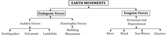
Earthquake
- The sudden movement or vibration on the Earth’s surface is called an earthquake.
- It is caused due to the release of energy which generates seismic waves, spreading in all directions.
- Before an earthquake, the amount of radon gas increases in the atmosphere. Hence, the increase in the amount of this gas is an indication of an earthquake in that particular region. The place from where seismic waves originate is called the focus.
- The place where seismic waves are first felt is called the epi-centre.Earthquakes are classified into three categories based on the depth of the earthquake origin:
- Normal earthquake – 0-50 km.
2. Intermediate earthquake – 50-250 km.
3. Deep or underground earthquake – 250-700 km.
(i) Primary or Longitudinal Waves
- These are also called P-waves.
- These are longitudinal waves and move like sound waves.
- This is the fastest among seismic waves, so it reaches the surface first.
- It can pass through solid as well as liquid and gaseous medium, although its speed becomes slower in liquid medium as compared to solid.
(ii) Secondary or Transverse Waves
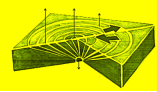
- These are also called S-waves. They travel like light waves.
- They can travel only in solid medium, and usually vanish in liquid medium. Since they cannot pass through the core of the earth, S-waves are used to infer that the core of the earth is liquid.
(iii) Surface or Long Period Waves
- These are also called L-waves. They affect only the upper part of the earth.
- These are the most influential waves and cover the longest path.
- Their speed is very slow and they reach the destination last, but their effect is the most destructive.
- The intensity of the earthquake gives information about the energy released. The sensitive instruments that measure the intensity of seismic waves are called seismographs. It has three scales-
- Rossi-Feral Scale – Its scales were kept between 1 to 11.
2. Mercalli Scale – This is an empirical scale. It has 12 scales.
3. Richter Scale- It is a logarithmic scale with intensity ranging from 0 to 10, with each subsequent unit on the Richter scale being 10 times more intense than the previous unit.
- The line joining the places having same seismic intensity is called isoseismal line or earthquake impact line.
- The line joining the seismic areas occurring at the same time is called homoseismal line.
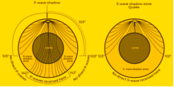
Global distribution of earthquakes
- Circum-Pacific Belt: This belt is along a path surrounding the Pacific Ocean. This zone includes the regions of great seismic activity such as Japan, the Philippines, and Chile. This path coincides with the Pacific Ring of Fire.
- Alpine-Himalayan Belt: Another major concentration of strong seismic activity runs through the mountainous regions that flank the Mediterranean Sea and extends through Iran and on past the Himalayan Mountains.
- Mid-Atlantic Ridge: a mid-ocean ridge that extends along the floor of the Atlantic Ocean in southern Europe.
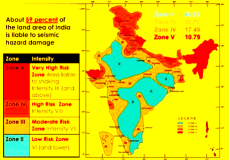
Seismic Zone Of India
| Zone | Intensity(M.M.) | Area |
| Zone-2:Low intensity | 6 or less | The remaining 46% of the country |
| Zone-3:Moderate Intensity | 7 | Kerala, Goa, Gujarat, Uttar Pradesh, West Bengal, parts of Punjab, Rajasthan, Madhya Pradesh, Bihar, Jharkhand, Chhattisgarh, Maharashtra, Odisha, Andhra Pradesh, Tamil Nadu and Karnataka |
| Zone-4: Very severeIntensity | 8 | Jammu & Kashmir, some areas of Himachal Pradesh, Delhi, Sikkim, Northern areas of Uttar Pradesh (Noida), Ganga-Yamuna Doab, Bihar, small area of Maharashtra along the west coast, Rajasthan, Delhi (Yamuna coast, East Delhi, Shahdara, Mayur Vihar, Laxmi Nagar), Gurgaon and Rewari. |
| Zone-5:Very high or severe intensity | 9 | North Eastern India, parts of Jammu and Kashmir, Himachal Pradesh, Uttarakhand, Rann of Kutch, parts of North Bihar, Andaman and Nicobar Islands. |
| Harmful Effects of Earthquake | |
| Landforms | Ground shaking, differential ground settlement, land and mudslides, soil liquefaction, ground lurching and avalanches. |
| Property | When earthquakes occur, buildings are greatly damaged. Underground pipelines and railway lines are damaged or broken. Dams on river collapse, resultant floods cause havoc. |
| Liquefaction | Underlying layer of water rich sand compacts and sends a column of water and fine sand up and out onto the surface.The depth of lakes etc. become lower and sand is pushed through the ground and the building sinks into the ground. |
| Human | Duration of tremors of an earthquake is normally only a few seconds, but thousands of people may die in this short period. |
| Fountain of Mud | Due to the intense impact of the earthquake, hot water and mud appear on the surface and take the form of fountains. In the Bihar earthquake of 1934, the fields of farmers were covered by knee-deep mud and crops destroyed. |
| Tsunami | Earthquakes can often result in tsunamis. It wreaks havoc on settlement of coastal areas. |
Volcano
- A volcano is a cavity or hole from which lava, ash, gas and water vapour erupt. Volcanic activity includes all the processes from the generation of magma and gas in the interior of the earth to the appearance of lava below and above the earth’s crust and its cooling and solidification.
- When the amount of silica in magma is high, explosive eruptions are seen in the volcano, whereas when the amount of silica is low, the eruption usually remains calm.
Cause Of Volcano
- Volcanoes can be formed along convergent, divergent and some continental plate boundaries.
- Subduction in case of convergent plate boundaries results in melting of rocks due to high temperature and pressure of one plate beneath another which moves along the cracks in the rocks.
- In case of divergent boundaries, thinning of the upper crust reduces the pressure on the rocks, which lowers the rock melting point and leads to formation of magma which flows out and erupts as lava from rift volcanoes.
- Some continental volcanoes are located away from plate boundaries due to the pressure of plates and formation of faults.
Classification of volcanoes
On the basis of activity, volcanoes are classified as follows
Active Volcanoes
- Volcanoes from which lava, gas and fragmented material keep coming out are called active volcanoes.
- Stromboli (Mediterranean lighthouse) of Lipari Island north of Sicily, Cotopaxi (world’s tallest active volcano), Antarctica’s only active volcano Mount Erebus, Fujiyama of Japan and Barren Island of Andaman-Nicobar (India’s only active) are other major active volcanoes.
Dormant Volcanoes
- These are the volcanoes which have not been active for years, but can explode anytime. Among them, Vesuvius of Italy, this mountain erupted once in recent years, due to which it should be placed in the category of active volcano.
- The volcanoes of Krakatoa of Indonesia and Narcondam Island of AndamanNicobar (signs of activity have been seen in it after the tsunami of December, 2004) are noteworthy.
Dead or Extinct Volcanoes
- This includes volcanoes which have not erupted for thousands of years and there is no possibility of it in the future.
- Elgon and Kilimanjaro in the eastern part of Africa, Chimbarazo in Ecuador, Popa in Myanmar, Demband and Koh Sultan in Iran and the Aconcagua mountain range in the Andes are major examples of this.
Volcanic Landforms
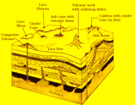
| Batholith | dome-like deposit of magma in any type of rock among the internal landforms formed by the deposition of volcanic lava |
| Laccolith | lava deposit in a convex slope and lapolith in a concave basin |
| Phacolith | internal lava deposit in the synclines and anticlines of folded mountains |
| Sill | The near horizontal bodies of the intrusive igneous rocks |
| Dykes | vertical deposits of lava considered the feeders for the eruptions that led to the development of the Deccan traps. |
| sheet | thin layer of sill |
| stack | smaller form of dyke |
Volcanic Activity
- The landforms created by the explosive eruption of a volcano include the formation of various types of volcanic cones on the outer parts.
- Sunken landforms like craters and calderas are formed on top of volcanic cones.
| Volcanic | Features |
| Shield Volcano | The largest of all volcanoes.Mostly composed of basalt, a type of lava that is very fluid when erupted.These volcanoes do not have steep slopes.They become explosive if water enters the vent.The volcanoes found in the Hawaiian Islands are of this type. |
| Mixed Volcano | These volcanoes erupt lava that is colder and more viscous than basalt.Material accumulated around the vent leads to the formation of layers, making the mountains appear as composite volcanoes.Examples of composite volcanoes include Mount Fuji, Japan. |
| Caldera | Most explosive of the earth’s volcanoes.Tend to collapse in on themselves rather than forming a tall structure.Collapsed craters are called calderas.Example: Lonar lake in Maharashtra. |
| Basalt Flow Field | Highly fluid lavaExample: The Deccan Traps of India is an extensive basalt lava flow region. |
RING OF FIRE
- The Ring of Fire is a long chain of volcanoes and other tectonically active structures that surround the Pacific ocean.
- Many of these volcanoes were created through the tectonic process of subduction.
- In general, foci of the earthquake in the areas of mid oceanic ridges are at shallow depths whereas along the Alpine-Himalayan belt as well as the rim of the Pacific, the earthquakes are deep-seated ones.
- Runs up along the western coast of South and North America, runs down the eastern coast of Asia past New Zealand and into the northern coast of Antarctica.