
| India an overview | |
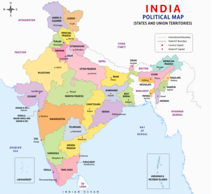
| Country – India / BharatOther Name – Aryavart, Jambudweep, Bharat Varsha, HindustanCapital – New DelhiNumber of States – 28Number of Union Territories – 8Geometrical Shape – QuadrilateralExtension of Mountainous Region – 10.7%Extension of Hill Area – 18.6Extension of Plateau Region – 27.7%Plain area expansion: 43.0%States Situated on Tropic of Cancer – 8 ( Gujarat, Rajasthan, Madhya Pradesh, Chhattisgarh, Jharkhand, West Bengal, Tripura, and Mizoram)States with International Boundaries – 18 | Geographical Location – Situated in North East HemisphereLatitudinal Extension – 8°4’ to 37°6’ North LatitudeLongitudinal Extension – 68°7’ East Longitude to 97°25’ East longitudeStandard Time – 82°30’ East longitude passes through Naini near Prayagraj , 5 hours 30 minutes ahead to GMT |
| Geographical Extension – length- (North to South 3,214 km) (Breadth- East to West 2,933 km)Land Boundary – 15,106.7 kmCoastline – 7,516.6 kmRegional Water Boundary – 12 oceanic mile to oceanic costExclusive Economic Zone – 200 nautical miles from Contiguous zoneContiguous Region – 24 Nautical mile from coastlineClimate – Monsoon Climate | Area – 32,87,263 km2Share in World’s Total Area – 2.42%Global Rank in Terms of Area – 7thNumber of National Highways – 59Number of Major Ports – 13Number of Refineries – 23 |
| National Animal – Tiger (Panthera tigris)National Heritage Animal – ElephantNational Bird – Peacock (Pavo cristatusNational Tree – Banyan (Ficus bengalensis)National Flower – Lotus (Nelumbo nucifera)National Emblem – Lion Capital of AshokaNational Anthem – Jana-Gana- ManaNational Song – Vande MatararamOfficial Language – HindiNational Script – DevanagariNational Quote – Satyamev JayateNational Flag – TricolorNational River – GangaNational Aquatic Animal – Gangetic Dolphin | Total Population (Census: 2011)-1,21,05,69,573 (17.5% of World’s total Population)Global Rank in Terms of Population – 2ndMale Population – 62,32,70,258Female Population – 58,75,84,719Rural Population – 83.37 Crore (68.8%)Urban Population – 37.71 Crore (31.2%)Decadal Growth of Population – 17.7% (2001-2011)Sex Ratio – 943 per thousand malesPopulation Density – 382 Persons per square kmTotal Literacy – 74.04% a. Male Literacy – 82.14% b. Female Literacy – 65.46%Schedule Caste Population – 20,13,78,086 (16.6% of total Population)Schedule Tribe Population – 10,42,81,034 (8.6% of total Population) |
- India stretches from the snow-capped peaks of the Himalayas to Indira Point, the southern tip of the Andaman and Nicobar Islands. It stretches from the fertile valleys of Arunachal Pradesh and the Brahmaputra in the east to the barren Thar desert in the west.
- The length of India’s border is approximately 15,200 km and the length of the coast of the mainland is 5422 km which including the coastal length of the islands it goes upto 7,516.6 km. India shares its border with Afghanistan, Pakistan, China, Nepal, Bhutan, Myanmar and Bangladesh. In the south, the Palk Strait separates India from Sri Lanka.
India’s border with neighboring countries
1. Afghanistan: Ladakh.
2. Bangladesh: Assam, Meghalaya, Mizoram, Tripura and West Bengal.
3. Bhutan: Arunachal Pradesh, Assam, Sikkim and West Bengal.
4. China: Arunachal Pradesh, Himachal Pradesh, Jammu and Kashmir, Sikkim and Uttarakhand.
5. Myanmar: Arunachal Pradesh, Manipur, Mizoram and Nagaland.
6. Nepal: Bihar, Sikkim, Uttarakhand, Uttar Pradesh and West Bengal.
7. Pakistan: Gujarat, Jammu and Kashmir, Punjab, Rajasthan and Ladakh.
International Borders of India
1. Wagah Border/Attari Border, Punjab (India – Pakistan)
2. Moreh, Manipur (India – Myanmar)
3. Nathula Pass, Sikkim (India – China)
4. Longewala, Rajasthan (India – Pakistan)
5. Dawki-Tamabil, Meghalaya (India – Bangladesh)
6. Rann of Kutch, Gujarat (India – Pakistan)
7. Pangong Lake, Ladakh (India – China)
8. Sonauli Border, Uttar Pradesh (India – Nepal)
9. Dhanushkodi, Tamil Nadu (India – Sri Lanka)
10. Jaigaon, West Bengal (India – Bhutan)
Four Corners of India
1. The Northernmost Point: The Indiracal-Siachin Glacier located in Ladakh is the northernmost point under the Line of Actual Control.
2. Southernmost Point: Kanyakumari, located in Tamil Nadu, is the southernmost point of mainland India, while Indira point is the southernmost point of India.
3. Easternmost Point : Kibithu, a small village located in the Lohit district of Arunachal Pradesh, is the easternmost point of India.
4. Westernmost Point: Guhar Moti, located in the Rann of Kutch in Gujarat, is the westernmost point of India.
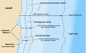
- Importance of the Indian Ocean India occupies the central position in the Indian Ocean and is the only country after which an ocean is named. The Indian Ocean holds considerable geopolitical, geostrategic, economic and trade importance for India. India’s territorial sea boundary or territorial sea extends up to a distance of 12 nautical miles from the coastal baseline. India has full rights to exploit all kinds of resources in this area. The baseline is actually an imaginary straight line joining the rugged coast. The sea water situated between the land and the baseline is called internal water. The distance of the contiguous zone or the area is 12 nautical miles from the territorial sea boundary and 24 nautical miles (1 nautical mile is 1.8 km) from the baseline.
- In this area, India has rights over immigration law, environmental cleanliness, financial rights for customs duty collection and fiscal rights. Exclusive Economic Zone (EEZ) is anarea up to 200 nautical miles from the coastal baseline, in which India has the right to sea water power, survey of marine resources, organisms, scientific research and exploitation of natural resources. After this area, there is an extension of High Sea, where all nations have equal rights.
- There are 28 states and 8 union territories in India. Our closest neighbours are Pakistan, Afghanistan, China, Nepal, Bhutan, Myanmar and Bangladesh. Nepal and Bhutan are buffer states between India and China. Sri Lanka is also a neighbouring country of India, which is separated from the mainland of India by the Palk Strait in the Indian Ocean. Adams Bridge is situated between Tamil Nadu and Sri Lanka. Pamban Island is a part of Adams Bridge. Rameswaram is situated on Pamban Island. Palk Strait is situatedto the north of Adams Bridge and Gulf of Mannar is situated to the south.
| Country | Length (km) | border Line | Indian states and union territories bordering India |
| Bangladesh | 4096.7 | 5 (West Bengal, Meghalaya, Mizoram, Tripura, Assam) | |
| China | 3488 | McMahon Line | 5 (Himachal Pradesh, Uttarakhand, Sikkim, Arunachal Pradesh and Ladakh) |
| Pakistan | 3323 | Radcliffe Line | 5 (Gujarat, Rajasthan, Punjab, Jammu and Kashmir, Ladakh |
| Nepal | 1751 | 5 (Uttar Pradesh, Bihar, West Bengal, Sikkim, Uttarakhand) | |
| Myanmar | 1643 | 4 (Arunachal Pradesh, Nagaland, Mizoram, Manipur) | |
| Bhutan | 699 | 4 (West Bengal, Sikkim, Arunachal Pradesh, Assam) | |
| Afghanistan | 106 | Durand Line | 1 (Ladakh |
| Total 7 country | 15106.7 | A total of 18 states and union territories share borders with the neighbouring country |