
General Introduction
- Distance from Sun: 149 Million Km (Average).
- Shape: Geoid (oblate spheroid) slightly flattened at the Poles and bulging at the Equator.
- Ratios: Land to water 3:7; Northern Hemisphere 2:3; Southern Hemisphere 1:4 (southern hemisphere has larger surface area under water)
- Speed of rotation around the axis is maximum at equator and decreases poleward.
- Earth lies in the Goldilocks Zone :- water can exist in a liquid state. It is the densest planet in the solar system.
- The position of any country or city on the surface of the earth is determined by latitude and longitude of that place.
- Latitude and longitude are determined (measured) in angular form.
- The rotation of the earth from west to east on its axis gives two natural reference points, which are called as the North and South Poles.
- Latitudes are divided between 0°(equator) to 90°(pole) while longitudes are divided between 0° (prime meridian) to 180° (international date line).
- An imaginary line connects the two poles, the midpoint of which is called the ‘axis’ of the earth. This axial line divides the earth into two important equal parts.
- The part situated between two latitudes and two longitudes is called the ‘grid’. Latitude and longitude lines cut each other at right angles.
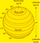
Latitude
- The angular distance measured from the centre of the earth to any point on a meridian north or south of the equator or the equator on the surface of the earth is called latitude.
- These circles are called latitude lines. In the northern and southern hemispheres, they are found from 0o to 90o . Thus, there are 181 latitude lines.
- In the northern hemisphere, 23½o north latitude is called the Tropic of Cancer and 66½o north latitude is called the northern sub-Arctic and in the southern hemisphere, 23½o south latitude is called the Tropic of Capricorn and 66½o south latitude is called the southern sub-polar circle.
- The latitudinal distance of every 1o is approximately 111 km. Which varies from the equator to the poles due to the spherical shape of the earth.
Some important latitude lines
(i) Equator-
- It is an imaginary line drawn on the Earth’s surface between the North Pole and the South Pole, at an equal distance from both poles, which divides the Earth into two equal parts (Northern Hemisphere and Southern Hemisphere). It is also known as the ‘zero degree latitude line’.
- The temperature on the Equator always remains high, due to which the annual and daily temperature difference is very low.
- The sun shines vertically on the Equator twice a year on 21 March and 23 September.
(ii) Tropic of cancer
- It is located at an angular distance of 23½° north from the Equator in the Northern Hemisphere.
- The Tropic of Cancer passes through Lake Nasser in Egypt and the Mahi River in India crosses it twice.
(iii) Tropic of Capricorn
- It is located in the Southern Hemisphere. The angular distance of 23½o south from the Equator represents the Tropic of Capricorn/Circle.
- It passes through the continents of South America, Africa and Australia.
(iv) Arctic Circle
- The angular distance of 66½o north from the Equator is known as the Arctic Circle.
- This circle also passes through the Great Bear Lake of Canada.
- The sun rays fall obliquely on the areas of the Arctic Circle, so it is a region with extremely cold climate.
(v) Antarctic Circle
- The angular distance of 66½o south from the Equator is known as the Antarctic Circle.
- Most of the Antarctic is always covered with ice that’s why called the ‘White Continent’.
| Passing through | Countries/States |
| Equator | 3 continents, 13 countries and 3 water bodies.Asia :- Maldives, Indonesia, Kiribati (Oceania).Africa :- Sao Tome and Principe, Gabon, Congo, Democratic Republic of Congo, Uganda, Kenya, Somalia.South America :- Ecuador, Colombia, Brazil.Water Bodies :- Atlantic Ocean, Pacific Ocean, Indian Ocean |
| Prime Meridian | passes through 3 continents, 8 countries and 6 water bodies.Europe :- UK, France, Spain.Africa :- Algeria, Mali, Burkina Faso, Ghana, TogoAntarctica.Water bodies :- Arctic Ocean, Norwegian Sea, Greenland Sea, Mediterranean Sea, Atlantic Ocean, Southern Ocean |
| Tropic of Cancer | passes through 3 continents, 16 countries and 6 water bodies.Asia :- Taiwan, China, Myanmar, Bangladesh, India, Oman, UAE, Saudi Arabia.Africa :- Egypt, Libya, Niger, Algeria, Mali, Western Sahara, Mauritania.North America: Bahamas (Archipelago), Mexico.India: Gujarat, Rajasthan, Madhya Pradesh, Chhattisgarh, Jharkhand, West Bengal, Tripura, Mizoram.Water bodies :- Indian Ocean, Atlantic Ocean, Pacific Ocean, Taiwan Strait, Red Sea, Gulf of Mexico |
| Tropic of Capricorn | Passes through 3 continents, 10 countries and 3 water bodies.South America :- Argentina, Brazil, Chile, ParaguayAfrica:- Namibia, Botswana, South Africa, Mozambique, MadagascarAustraliaWater bodies: Indian Ocean, Atlantic Ocean, Pacific Ocean |
| Indian Standard Time (82½° E Meridian) | Uttar Pradesh, Madhya Pradesh, Chhattisgarh, Odisha, Andhra Pradesh. |
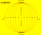
Longitude
- The angular distance of a place to the east or west of the prime meridian is called longitude.
- Prime Meridian is considered to be 0o longitude. It passes through Greenwich in London.
- There are longitudes up to 180o on either side of 0o , which are 360o in total.
- The distance of 1o longitude on the equator is 111.32 km, which gradually decreases towards the poles. All longitudes up to 180o situated east of Greenwich line are called eastern longitudes and all longitudes situated towards the west are called western longitudes. These are called Eastern Hemisphere and Western Hemisphere .
GREENWICH MEAN TIME (GMT)
- It is the name for mean solar time of the longitude (0°) of the Royal Greenwich Observatory in England. The meridian at this longitude is called the prime meridian or Greenwich meridian.
- Local Time with respect to GMT :
- Earth rotates from West to East, so every 15° we go eastward, local time is advanced by 1 hour.
- If we go westward, local time is retarded by one hour.
- India is 5 hrs 30 min ahead of GMT.
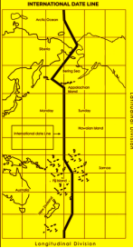
- From Greenwich to 180°E, gain of 12 hours, similarly from Greenwich to 180°W Lose 12 hours. Thus, a difference of 24 hours between the two sides of the 180°meridian. This is the International Date Line (IDL).
International Date Line
- The imaginary line drawn on the earth around 180o meridian, leaving out the landmasses, is called the International Date Line.
- It is bent towards the east at 75o north latitude to separate Siberia from Alaska.
- This line is bent towards the west in the Bering Sea.
- This line is bent towards the east in the South Pacific Ocean to keep the Fiji Islands and various parts of New Zealand together.
- There is a difference of one day between the east and west of the International Date Line. Hence, one day is added or subtracted while crossing it.
- When a ship crosses the International Date Line and travels in the west direction, one day is added and when it travels in the east direction, one day is subtracted.
Standard Time
- It is the mean of the meridian passing through the middle of a country, which is considered applicable for the whole country due to the inconvenience of local time.
- The time of 82½o East Meridian which passes through Naini near Prayagraj is the standard time for the whole of India. This eliminates the problem of adjusting the time difference due to longitude difference in different parts of India.
Local Time
- It is the time calculated from the position of the sun at a particular place on earth.
- Local midday time is the time when the sun shines perpendicularly at that particular place.
- There is a difference of about two hours between the local time of places situated in the extreme east (Kibithu, Arunachal Pradesh) and extreme west (Guharmoti, Gujarat) of India. The difference between the standard time of India and GMT is 5 hours 30 minutes.
Heat Zones Of The Earth
- The earth is divided into three temperature zones namely tropical zone, temperate zone and cold zone.
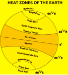
| Parameter | Torrid/Tropical Zone | Temperate Zone | Frigid Zone |
| Mid-day Sun | Exactly overhead | Never shines overhead on any latitude beyond the Tropics | The sun does not rise much above the horizon. |
| Heat | Maximum | Moderate | Least (very Cold) |