
- That branch of geography which studies the present relief features of the earth’s surface or of natural features in their causal relationship.
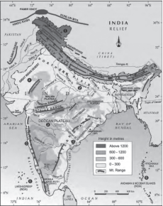
- India has a unique personality with respect to physiography.India is a huge country with various landforms. Many types of landforms are found here. For example, mountains, plateaus, plains and islands etc.
1. Plains: 43% 2. Mountains: 10.7%
3. Hilly: 18.6% 4. Plateau: 27.7%
- On the basis of topography and structure, India can be divided into six major landform divisions-
1) Northern and NorthEastern Himalayas
2) The Great Plains of Northern India
3) Indian Desert
4) Peninsular Plateau
5) Coastal Plains
6) Islands of India
Northern and Northeastern Himalayas
- The world’s highest and largest mountain range (Himalaya mountainrange) is spread from east to west on the northern border of India. This is the world’s newest folded mountain range. In the western part of this mountain range, near Nanga Parbat and in the eastern part near Mishmi Hills or Namcha Barwa, two sharp syntaxial bends are found like hairpin turns. These have been formed due to the north-eastern pressure of the peninsular plateau region. The mountain ranges of the Himalayas have become convex towards the peninsular plateau and concave towards Tibet. The width of the mountain region decreases and the height increases from west to east, as a result of which the slope also becomes steeper.
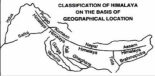
The Northern Mountains
- Divided into three groups.
1. The Himalayas
2. The Trans Himalayas
3. The Purvanchal/ Eastern hills in North East
- The Himalayas
- The Himalayas are the youngest mountains and highest mountain range in the world.
- Himalayas act as a natural barrier due to the extreme cold, snow and rugged topography against the infiltration.
- They run from west-east direction from Indus to Brahmaputra along the northern boundary of India.
- Its width is maximum in Kashmir (500 km) and minimum in Arunachal (200 km).
- The Pamir (roof of the world) is the connecting link between the Himalayas and the Central Asian peaks.
- The southern boundary is well defined by the foothills while the northern boundary is obscure and merges with the Tibetan plateau.
- Individual ranges have steep gradients towards the south but a gentler slope towards the north.
Origin of Himalayas
- It is agreed unanimously that they have come out of a great geosyncline called the Tethys sea and they have developed in phases (Greater-Middle-Shiwalik). However, there are divergent views about the process involved and forces responsible.
- About 120 MYA Pangea existed with N America and Eurasia in its north which was called Angaraland And Laurasia.
- The southern part of Pangea had S America, Australia, Africa, S India and Antarctica; and was called Gondwanaland.
- In between Angaraland and Gondwanaland, there was a long, narrow sea called the Tethys sea.
- Sediments deposited from rivers of both the continents were deposited in the Tethys sea. (Relate to Brahamputra being antecedent i.e., existed before the Himalayas).
- These sediments were subjected to forces of compression which led to a series of folds one behind another giving birth to the Himalayas.
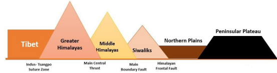
- Division of Himalayas
- Greater himalayas of himadri
- Lesser himalayas of himachal
- Outer himalayas or siwaliks
A. Greater Himalayas or Himadri:
- Northernmost range also known as inner or central or Himadri Himalayas.
- It terminates abruptly in Nanga Parbat in NW and Namcha Barwa in the NE.
- Peaks in descending order: Kanchenjunga > Lhotse > Makalu > Dhaulagiri > Manaslu > Nanga Parbat > Annapurna.
- These mountains are so formidable that they cannot be crossed easily even through passes as they are snowbound most of the time.
| Important Peaks | Nanda Devi, Kamet, Namcha Barwa, Badri Nath, Trisul. |
| Important Passes | Burzil and Zojila in Kashmir.Baralacha la and Shipkila in Himachal.Thaga la, Nitipaas and Lipulekh in Uttarakhand.Nathu la and Jelep la in Sikkim |
B. Lesser Himalayas or Himachal:
- These lie in between Shivalik in the south and greater Himalayas in the north.
- Majority of hill resorts are located here. E.g., Shimla, Ranikhet, Nainital, Almora and Darjeeling etc.
- Important Ranges:
- Dhaula Dhar, PirPanjal: In Kashmir is the longest most important range. It extends from Jhelum to Beas and is separated from the Zanskar range by the Kashmir valley.
- Mussoorie: From Mussoorie to Lansdowne.
- Nag Tibba.
- Mahabharat Lekh: In Nepal, is a continuation of Mussoorie ranges.
C. Outer Himalayas or Siwaliks:
- With its southern steep slopes, it assumes hogback appearance.
- Runs parallel to lesser Himalayas from Potwar plateau to Brahmaputra valley.
- Except for 80-90 km in which Teesta flows, this is almost an unbroken series of low hills.
- They comprise of :-
- Jammu Hills (Jammu and Dafla)
- Miri, Abhor and Mishmi (Arunachal)
- Dhang and Dudhwa range (Uttarakhand)
- Churia Ghat (Nepal)
| Duns/Doons | Shivalik hills formed after the Himalayas and obstructed rivers coming from Himalayas and formed temporary lakes.The debris brought by the rivers were deposited in these lakes. After rivers cut through the Shiwalik, these lakes dried up and left behind Duns or Doons. E.g., Dehradun. |
| Chos | The southern slopes are devoid of any vegetation in Punjab and Himachal and are highly dissected by several streams known as chos |
- Trans Himalayan Region
- This is the northern part of the Greater Himalayas. It includes the mountain ranges of Karakoram, Ladakh, Zaskar etc. which were formed even before the Himalayas.
- These are mainly found in the western Himalayan region. K2 or Godwin Austin (8611m) is the highest peak of the Karakoram range which is the highest peak of India. The Karakoram range is called the backbone of high Asia, which is located in the Indian territory (Pakistan occupied Kashmir).
- The Trans Himalayas are separated from the Greater Himalayas by the Indus-Tsangpo Suture zone. Many large glaciers are found here whose order from west to east is Batura → Biafo →Hispar → Baltoro → Siachen.
3.The Purvanchal Himalayas/Eastern Hills in North East
- After crossing the Dihang turn the Himalayas take a sudden turn and form a series of comparatively low hills running in the shape of a crescent.
- From Arunachal to Mizoram, they form India’s border with Myanmar.
- Height decreases as we move from North to South and although low in elevation, these hills are formidable due to rough terrain, dense forests and swift streams.
| Important PeaksPatkai bum forms international boundary between Arunachal and Myanmar.After a while it merges into the Naga hills where Saramati peak is the highest.Patkai bum and Naga hills form the watershed between India and Myanmar.Kohima hills to the west are made up of sandstone and slate and have rough topography.South of naga hills is the Manipur hills which forms the boundary between Manipur and Myanmar.The Barail ranges separate Naga and Manipur hills.Jaintia, khasi and Garo hills are eastward continuation .Peninsular block (and not part of Northern plains).Mizo hills or Lushai hills are south of Manipur hills. |
Passes in India
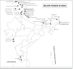
- Many passes such as Karakoram, Shipkila, Nathula, Bomdila etc. are also found in the Himalayan region. The Karakoram Pass located in Ladakh is one of the highest passes (5654 m) of India. A road going to China has also been built from here.
- Burzil Pass connects Srinagar to Gilgit.
- Zojila Pass is located in the Zaskar range, the route from Srinagar to Leh passes through it.
- The route from Kulgaon to Kothi passes through the Pirpanjal Pass.
- The route from Jammu to Srinagar passes through the Banihal Pass. Jawahar Tunnel is also located in this part.
- The highest pass in India is Yangze Diwan (5890 meters).
- Shipkila Pass connects Shimla to Tibet.
- The route from Mandi to Leh passes through the Baralachala Pass.
- Thangla, Mana, Niti and Lipulekh Pass are located in the Kumaon range of Uttarakhand, the route to Mansarovar Lake and Kailash Valley passes through the Lipulekh Pass.
- Nathula and Jalepla passes located in Sikkim have immense strategic importance. From here, there is a route to Tibet through Darjeeling and Chumbi Valley
- Bomdila and Yonggyap passes are located in Arunachal Pradesh. Bomdila pass is the route to Tibet through Tawang Valley. Brahmaputra river enters India near Yangyap pass. There is also a route to China from here.
- Diphu and Pang saw passes are located on the Indo-Myanmar border in Arunachal Pradesh.
- The route from Imphal to Tamu and Myanmar passes through Tuju pass located in Manipur.
| Important Passes of Himalayas | |
| Jammu and Kashmir | Mintaka pass: Near the tri junction of India-Afghanistan- China.Aghil pass: North of K2, joins Ladakh with Xinjiang. Remains closed in winters.Banihal pass: Across PirPanjal range and remains closed for winters.Khardungla: Near Leh in the Ladakh range and remains closed in winters. World’s highest motorable road passes through this pass.Pir-Panjal pass: A traditional pass on Mughal road and provides shortest and easiest link between Jammu and Kashmir but closed since partition.Zoji la: Provides important links between Srinagar and kargil and kargil and Leh. |
| Himachal Pradesh | Bara Lacha la: Provides link between Himachal and Jammu and Kashmir. NH connecting Mandi and Leh passes through here.Rohtang pass: Provides link between Kullu, Lahaul and Spiti. Shipki La: At Indo-China border and provides link between Himachal and Tibet. Remains snow bound for most part of winter. |
| Uttarakhand | Lipulekh: At the trijunction of India-China- Nepal in Pithoragarh district links India with Tibet. Mana pass: Little bit north of Badrinath Dham near the Indo-China border. It connects Uttarakhand with Tibet. Remains closed for 6 months due to snowfall.Mangsha Dhura: At Indo-China border in Pithoragarh and connects India and Tibet. Used as a route to Kailash Mansarovar.Niti pass: At the Indo-China border across the great Himalayas and joins Uttarakhand with Tibet. |
| Sikkim | Nathu la: At Indo-China border and forms an offshoot of ancient silk route. Connects Sikkim with Tibet.Jelep la: Passes through Chumbi valley and is an important link between Sikkim and Lhasa. |
• The ancient rivers like Indus, Sutlej, Brahmaputra (Tsangpo) etc. have created deep
valleys, gorges and canyons in the Himalayan region. These have been created by
continuous erosion by these rivers during the rise of the Himalayas. Various rivers have
separated the Himalayan region into four major natural parts:-
(i) Kashmir or Punjab Himalaya
- It is spread in Jammu-Kashmir and Himachal Pradesh in a length of 560 km between Indus and Sutlej rivers. Here the Himalayas gradually gain height. Zaskar, Ladakh, Karakoram, Pirpanjal and Dhauladhar ranges are its parts. The width of the Himalayas is maximum here and it is spread in an area of 250 to 400 km.
(ii) Kumaon Himalaya
- It is a part of Himachal Himalaya between Sutlej and Kali rivers which is spread in the state of Uttarakhand in a length of 320 km. Nanda Devi, Kamet, Badrinath, Kedarnath, Trishul etc. are its major peaks. Nanda Devi is the highest peak of this range, which is the third highest peak of India.
(iii) Nepal Himalayas
- It is spread over a length of 800 km between the Kali and Teesta rivers. The width of the Himalayas is very less here but the highest peaks of the Himalayas are found here, such as Everest, Kanchenjunga, Makalu etc.
(iv) Assam Himalaya
- It is spread over a length of 720 km between the Teesta and Dihang (SangpoBrahmaputra) rivers in the states of Sikkim, Assam and Arunachal Pradesh and the country of Bhutan. Here the height of the Himalayas starts decreasing again
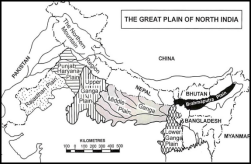
Great Plain of Northern India
- It is an aggregational plain formed by the deposition of three major river systems- Indus, Ganga, and Brahmaputra.These are also called the plains of Ganga and Brahmaputra.
- This plain is spread from the Indus River in the west to the Brahmaputra River in the east. It is a flat plain and there is very little difference in its topography. This plain is about 3,200 kilometers long from east to west and about 150 to 300 kilometers wide
- The height of this plain from sea level is about 50 to 150 meters. The fertile soil, suitable climate and adequate water supply of this region are very helpful in the development of agriculture.
- It is the largest alluvial tract of the world.
- Its width decreases from west to east.
- Its northern boundary is well defined by the Shiwalik, but the southern boundary is not well marked.
Origin of the plains
- The rivers filled up the deep depression between the plains and the Himalayas. There are debates about whether the depression was a geosyncline or a fault or something else.
- But most geologists agree that the Tethyssea sediments were compressed and risen to form the Himalayas and a trough.
- The great plains represent Himalayas pushing towards the north.
- They are not flat and featureless.
- The northern plains have been divided into five important regions on the basis of topography and physical features – Bhabar, Terai, Bhangar, Khadar and Delta
| Bhabar | The area from Indus river to Teesta river in the Shivalik foothills in North India is called ‘Bhabhar’. This landmass is made up of the deposition of stones, pebbles, gravel etc. brought by the Himalayan rivers.Its width is generally 8 to 10 km.In this landmass, small rivers become invisible due to flowing under the piles of stones, pebbles, gravel.This area is not suitable for agriculture. |
| Terai | This region is a marshy area to the south of Bhabar region and is made up of fine pebbles, stones, sand and clay soil. Its width is generally 10 to 20 km.The rivers which disappear in the Bhabar region, become visible again in the ground of the Terai region. Due to excess rainfall, the Terai region is more spread out in the east than in the west.Due to the lack of slope in this region, water remains scattered. Due to which the land of this region is always moist and is more suitable for agriculture, especially sugarcane & rice. |
| Bhangar | This is the high land of the northern plain which is made up of old alluvial soil.The largest part of the northern plain is made up of old alluvium (Bhangar).Its expansion is mainly found in the plains of Punjab and Uttar Pradesh.Pebbles are also found in it. In dry areas, saline and alkaline swellings are seen in it, which are called ‘Reh’ or ‘Kallar’ (Usara soil).The Bhangar region is located above the level of the flood plain of the rivers, so the flood water of the rivers does not reach here.This region is less useful for agriculture and the depth of the underground water level is more in it.In the Bhangar region, due to weathering, the soft soil on the top of the land has been destroyed and now elevated, undulating soil is found there. Such land is called ‘Bhur’. |
| khadar | This is the low land of the plains of northern India which is made up of new alluvial soil. It is spread in eastern Uttar Pradesh, Bihar and West Bengal.Khadar region is located in the lower part of the rivers, on which a new layer of alluvium gets deposited during floods.This area is very fertile for agriculture. The underground water level in it is high.The soil of Khadar land has abundance of ‘Clay’, which gives it the ability to retain moisture.This area/soil is famous for the cultivation of rice, jute, wheat, sugarcane, pulses, oilseeds etc. |
| Delta | It is an extended part of the Khadar plain.It is found in the lower Ganga valley (West Bengal).It includes old and new mud and swamps.The high land here is called ‘Char’. |
The vast plain of northern India is mainly divided into four sub-classes on the regional basis :-
- Rajasthan Plain
- Punjab – haryana Plain
- Ganga Plain
- Brahmaputra Plain
Rajasthan Plain
- Its extension is from the Aravalli Mountains in the west to the India-Pakistan border, the Punjab-Haryana plains in the north and the Gujarat plains in the south.
- The Aravalli Mountains act as a dividing line between the Rajasthan plains and the central highlands.
- The 25 cm isohyet line is the dividing line between ‘Rajasthan Bagar’ and ‘Thar Desert’ in the Rajasthan plains. The fertile land of Rajasthan Bagar is called ‘Rohi’.
- The Thar Desert in the Rajasthan plains is an important region of India in terms of mineral oil, gypsum and salt reserves. ‘Indira Gandhi Canal’ has been developed here for water resources for agriculture.
- ‘Sambhar Lake’ in the Rajasthan plains is India’s largest inland ‘salt water lake’ and ‘Luni’ is a major river of this plain.
- In this region, a wide flat trough with centripetal drainage surrounded by hills is called ‘Bolsons’. Small lakes with flat and flowing basins are called ‘Playa’.
- Sambhar Lake is a good example of ‘Bolson’. Didwana, Kuchaman, Sargol and other lakes are examples of ‘Playa’.
- Sand dunes and barkhans are found in the entire desert region. A large part of the Rajasthan plain is covered with sand dunes.
Punjab-Haryana plain
- Parts of it are formed by deposition of five riversSutlej, Beas, Ravi, Chenab, Jhelum. It is primarily made up of DOABS i.e., land between rivers.
- There are 5 prominent doabs from east to west: (starting letter of the two rivers involved)
- Bist- Between Beas and Sutlej
- Bari- Between Beas and Ravi
- Rachna- Between Ravi and Chenab
- Chaj- Between Chenab and Jhelum
- Sind Sagar Doab- Between Jhelum, Chenab, and Indus.
- The Dhayas are broad flood plains of khadar and the khadar belt themselves are called Bet Lands.
- Numerous local streams exist called Chos.
- The area between Ghaggar and Yamuna is in Haryana and is called Haryana Tract. It acts like a watershed between Yamuna and Sutlej.
- Ghaggar is considered the successor of Saraswati.
Gangetic Plain
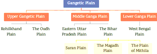
- It extends to Uttar Pradesh, Bihar and West Bengal.
- The plain formed by the Ganga and its tributaries is mainly demarcated into three plain regions :-Upper Ganga Plain > Middle Ganga Plain > Lower Ganga Plain
- Upper Ganga Plain :- Extends from Shiwalik in the North, Yamuna in the west and Peninsular boundary in the south. The western part has the Ganga-Yamuna doab, the east has Rohilkhand plains.
- Middle Ganga plain :- Occupies eastern part of Uttar Pradesh and Bihar. The plain is drained by many tributaries of Ganga. The area is prone to frequent floods.
- The lower Ganga plain :- Mostly in West Bengal and parts in Bangladesh. It starts from the foot of Darjeeling Himalayas and ends in the Bay of Bengal. The area is marked by Duars and Barind plains. The delta of Ganga is in this division and has a large number of mud flats, sandbanks, estuaries and world-famous Sundarbans.
- The Ganga Plain is formed in a ‘Foredeep’ basin. When the peninsular landmass stopped the southern expansion of the Himalayas, a foredeep was formed in front of the high folds of the Himalayas, which gradually got filled with sediments brought by the rivers originating from the Himalayas, which ultimately led to the formation of the vast Ganga Plain.
- Going from east to west in the Ganga Plain, the amount of rainfall caused by the Bay of Bengal branch keeps on decreasing due to increasing distance from the sea.
- The middle Ganga Plain is the most affected area by floods.
- ‘Oxbow or Gokhur Lakes’ are found more in the middle Ganga Plain because in this part the rivers flow in the form of meanders.
- Troughs are found here and there in the Ganga Plain, which are called ‘Jalla’ near Patna and ‘Tal’ near Mokama. In West Bengal such water filled troughs are called ‘Beel’.
- The hilly and Terai region of Jalpaiguri and Darjeeling districts is called ‘Duar’.
The Brahmaputra Plain
- This plain is the far eastern part of the vast plain drained by the Brahmaputra and its tributaries.
- Although it is treated sometimes an extension of the Gangetic plains, it is well demarcated by:
- Eastern Himalayas of Arunachal.
- Patkai & Naga hills in the East.
- Garo-Khasi-Jainita and Mikir in the south.
- Lower Ganga plain and Bangladesh border in the west.
- The general slope of the plain is towards the south-west towards the Bay of Bengal. Due to the low slope gradient, many river islands have been formed in this region, such as Majuli Island.
- The slope of the northern banks of the Assam valley is steep but the slope of the southern bank is found to be gentle towards Meghalaya.
- This plain is one of the most fertile plains of India and mainly rice and jute are cultivated here.
- In some parts of the Brahmaputra plain, due to the obstruction of the flow path by the formation of cones formed by the tributary rivers, oxbow lakes, beels, swamps and Terai areas have been formed.
- Brahmaputra enters this plain near Sadiya and flows farther to Bangladesh after turning southwards near Dhubri.
The Indian Desert
- This region has semi-arid and arid weather conditions (less than 150 mm of rainfall per year).The area receiving 25 cm annual rainfall or less is classified as a desert.
- Luni is the main river in this area. All other streams appear only at the time of rainfall otherwise they disappear into the sand.
- In India, on the north-western and western edge of the Aravalli hills, there is an undulating desert plain covered with sand dunes, which is called the ‘Thar Desert’. It is the ninth largest desert in the world.
- Most of the Thar Desert is located in Rajasthan, but some parts are also spread in Punjab, Haryana and Gujarat.
- The highest population density in the desert areas of the world is found in the ‘Thar Desert’.
- On the basis of slope, the Thar Desert can be divided mainly into two parts – (i) Northern part, whose slope is towards the Sindh province of Pakistan (ii) Southern part, whose slope is towards the Rann of Kutch.
- Rann of Kutch is also called the ‘White Desert’. This area is made up of salty marshes which are spread over thousands of square km.
- The geological rock structure of this region is an extension of the peninsular plateau but the surface topography here is formed by physical weathering and winds, such as sand dunes, barkhans, umbrellas etc.
Peninsular Plateau
- The Peninsular Plateau of India is an irregular triangular shaped landmass, which extends from the Aravalli Range and Delhi in the North-West, Rajmahal Hills in the East, Gir Hills in the West, Cardamom Hills in the South and Shillong and karbianglong Plateau in the North-East. Its average height is 600-900 meters.
- It was formed due to the breakup of Gondwanaland and its flow towards the north. Hence, it is a part of the oldest landmass Pangea, which is made up of old crystalline, igneous and metamorphic rocks.
- It is roughly triangular with its base coinciding with the southern edge of the great plain and surrounded by hills on all three sides:
- North: Aravallis, Satpura, Vindhyas, Bharmer and Rajmahal.
- South: Western and eastern ghats.
- Generally, the height of the peninsula decreases from west to east, which is the reason that most of the rivers of the Peninsular Plateau flow from west to east.
- The slope of the Peninsular Plateau is towards north and east, which is evident from the flow of Son, Chambal and Damodar rivers. In the southern part, its slope is from west to east, which is evident from the flow of Godavari, Krishna, Mahanadi, Kaveri rivers.
- Among the peninsular rivers, Narmada and Tapti rivers are exceptions because their direction of flow is from east to west. This is due to flowing through a fault valley.
- The peninsular plateau is called the ‘plateau of plateaus’ because it is made up of many plateaus-
- Central Highlands,
- Eastern Plateau,
- North-Eastern Plateau,
- Deccan Plateau
- The Central Highlands
• The following areas are included under the Central Highlands-
- Aravalli mountain range
- Mewar plateau
- Malwa plateau
- Bundelkhand plateau
- Vindhya range
- Satpura range
- Aravalli ranges
- Running in NE to SW direction between Delhi and Palanpur in Gujarat.
- Aravalli ranges represent the relict of the world’soldest mountains.
- Its NE end is marked by the Delhi ridge, in the SW is Mount Abu separated by the valley of Banas.
- Guru Shikhar is the highest peak.
- Mewar Plateau
- The Mewar Plateau is spread across Rajasthan and Madhya Pradesh. The Mewar Plateau is a structure that separates the Aravalli Mountains from the Malwa Plateau.
- It falls in the drainage area of the Banas River originating from the Aravalli Mountains. The Banas River is an important tributary of the Chambal River
- It is made up of sandstone, shale and limestones of the Vindhyan period.
- Malwa Plateau
- Between the Aravallis in the west and Bundelkhand in the east.
- It has two drainage systemsone towards the Arabian sea and the other towards the Bay of Bengal.
- It is composed of extensive lava flow and is covered with black soil. Black soil has developed here due to weathering in basalt rock, hence Malwa plateau region is useful for cotton cultivation
- There are rolling surfaces and flat-topped hills dissected by rivers.
- Chambal, Narmada and Tapi are the major rivers here. Chambal river valley is the most affected area by gully erosion in India, which is called ‘ravine or bad land’.
- Bundelkhand Plateau
- It is spread between the Gwalior plateau and the Vindhyachal range in the states of Madhya Pradesh and Uttar Pradesh.
- It includes seven districts of Uttar Pradesh (Jalaun, Jhansi, Lalitpur, Chitrakoot, Hamirpur, Banda, Mahoba) and eight districts of Madhya Pradesh (Datia, Niwari, Tikamgarh, Chhatarpur, Panna, Damoh, Sagar, Vidisha).
- Due to weathering and erosion of the granite and gneiss rock structure here, red soil has developed.
- The great ravines formed by the Chambal river, a tributary of Yamuna, in the Bundelkhand plateau are called the ‘region of ravaged land’.
- The Bundelkhand region is an economically backward region of the central highlands due to being a drought-affected area.
- The Baghelkhand plateau, located on the border of Madhya Pradesh and Chhattisgarh, separates the central highlands from the eastern plateau.
- Vindhyas
- Rise as escarpment north of Narmada-Son trough.
- It runs parallel to Narmada from east to west from Gujarat to Sasaram in Bihar.
- The western part is covered with lava.
- In the east Bharner and Kaimur hills are part of Vindhyas.
- It acts as a watershed between the Ganga system and rivers of South India.
F.Satpura Range
- It is located in the central part of India, extending from Gujarat to Madhya Pradesh, Maharashtra border to Chhattisgarh and Chotanagpur plateau.
- It is spread from west to east in the form of Rajpipla hill, Mahadev hill and Maikal range. The highest peak of this mountain range is ‘Dhoopgarh’ (1,350 m) which is situated on Mahadev mountain. The highest peak of Maikal range is ‘Amarkantak’ (1,065 m). (In some other sources, its many other heights are given). Narmada and Son rivers originate from here.
- It is a block mountain, which is mainly formed from granite and basalt rocks. This mountain range acts as a water divide between Narmada and Tapi rivers.
Eastern Plateau
- Chotanagpur Plateau
- Chattisgarh Basin Mahanadi Basin
- Dandakaranya Plateau
- Chotanagpur Plateau
- It is mainly spread in Jharkhand. Apart from this, southern Bihar, northern Chhattisgarh, Purulia district of West Bengal and northern region of Odisha also fall in the Chotanagpur plateau region.
- Rajmahal hill is in the north-east of this plateau, Hazaribagh plateau in the north and Ranchi plateau in the south. These three structures are jointly included in the Chotanagpur plateau region.Damodar river separates Ranchi plateau from Hazaribagh plateau. It is the largest river of Chotanagpur plateau.The Damodar river flows through the middle of the plateau in a rift valley from west to east.
- Damodar river basin is the most important region of India in terms of coal reserves.
- North of Damodar is the Hazaribagh plateau with isolated hills and Parasnath peak is the highest.
- Subarnarekha river originating from Ranchi plateau is the second largest river of Chotanagpur. ‘Hundru waterfall’ is on this river near Ranchi. The high topography made of granite rock in the Chhotanagpur plateau region is called ‘Pat Land’. From the viewpoint of geological structure, the Pat region is an example of an ‘elevated land’.
- East of Baghelkhand represents the NE projection of the Peninsula.
- The Rajmahal hills to the North edge are mostly made of Basalt and covered by lava flows.
- Chhattisgarh Basin Mahanadi Basin
- Chhattisgarh Basin is spread in Chhattisgarh and Odisha states, which is formed by the process of subsidence.
- Chhattisgarh Basin separates Ranchi Plateau of Chotanagpur from Dandakaranya Plateau and is itself separated from Ranchi Plateau of Chotanagpur Plateau by Mahanadi.
- Mahanadi and its tributaries- Sheonath, Hasdo, Mand, Ib etc. flow here.
- Gondwana series structure is found in Chhattisgarh Basin, due to which there is abundant availability of coal reserves here.
- Dandakaranya Plateau
- It extends to Odisha, Chhattisgarh, Maharashtra, Andhra Pradesh and Telangana. Hence it is located in the central part of India.
- It is a very rugged and infertile region, but is important from the point of view of mineral resources.
- Godavari’s tributary river ‘Indravati’ originates from this region.
- In India, ‘tin metal’ is found in ‘Bastar’ region located in Dandakaranya plateau.
North-eastern Plateau
Meghalaya Plateau
- Part of peninsular India and extends further NE beyond the Rajmahal hills and forms a rectangular block known as Meghalaya or the Shillong plateau. the Meghalaya plateau is the eastern extension of the peninsular plateau (Chhotanagpur plateau), which is separated by the ‘Rajmahal-Garo Gap’ or ‘Malda Gap’.
- It is separated from the main peninsula by the RajmahalGaro gap now filled by sediments of Ganga.
- In this plateau, from west to east, the Garo, Khasi, Jaintia and Mikir hills are situated, which are made of ancient rocks.
- Garo, Khasi, Jaintia are the main tribes living in this plateau.
- Due to the Khasi hill region being situated in the form of a ‘funnel’, there is more rainfall than average here. This is the reason that ‘Mawsynram’ and ‘Cherrapunji’ located to the south of the Khasi hills are counted among the wettest areas in the world.
- Due to above average rainfall, ‘laterite soil’ and evergreen forests have developed here.
- Shillong is the highest point of the plateau.
The Deccan Plateau
- This plateau is spread in a triangular shape to the south of Tapi river.
- Deccan Trap
- Karnataka Plateau
- Andhra Plateau
- Deccan Traps
- Due to the structure made of basalt rock in Maharashtra, ‘black soil’ has developed here, so this area is most important from the point of view of cotton production.
- It extends from north of 16° north latitude to Nagpur in the north-east.
- Hills like Satmala, Ajanta, Balaghat and Harishchandra are also spread in this plateau region.
- Largest unit of the peninsula.
- Bounded by Satpura and Vindhyas in the North-West, Mahadeva and Maikal in the North,Western ghats in the West and Eastern ghats in the East.
- Its general slope is from west to east indicated by flow of major rivers like Mahanadi, Godavari, Krishna and Cauvery.
- It is subdivided into smaller plateaus :- The Maharashtra plateau , The Karnataka plateau, Telangana plateau ,Chhattisgarh
- Karnataka Plateau
- In the plateau region of Karnataka, the mountainous and plateau region attached to the Western Ghats is called ‘Malnad’. ‘Baba Budan’ is the highest mountainous region here and ‘Mullayanagiri’ (Mullangiri) is its highest peak. (Kudremukh is shown as the highest peak of Baba Budan in the Oxford Atlas.)
- The relatively low-elevation plateau region attached to Malnad in the east is called ‘Maidan’, in which the higher-than-average plains are known as ‘Bangalore Plateau’ and ‘Mysore Plateau’.
- Due to the development of Dharwad structure in Karnataka, the plateau region is important from the point of view of reserves of metallic mineral resources.
- It has the largest reserves of iron ore, for which the Baba Budan mountainous region is more important.
- The drainage area of the Kaveri River is in the Mysore Plateau. • Krishna, Kaveri, Tungabhadra, Sharavati and Bhima are the major rivers here. India’s important waterfall is on the Sharavati river, which is called ‘Jog or Gersoppa’ waterfall. It is also called ‘Mahatma Gandhi’ waterfall.
- Kunchikal waterfall is India’s highest waterfall (455 meters), which is on the ‘Varahi river’ in Shimoga district (Karnataka). (Based on current sources)
- Andhra Plateau
- ‘Rayalaseema Plateau’ and ‘Telangana Plateau’ are included in the Andhra Plateau.
- The plateau region south of the Krishna River Basin is called the ‘Rayalaseema Plateau’, where Velikonda, Palakonda and Nallamalai mountains are spread, while the plateau region north of the Krishna River Basin is called the ‘Telangana Plateau’.
- The upper part of the Telangana Plateau is a plateau and the southern part is a fertile plain.
Southern mountainous region
- The southern mountainous region includes Nilgiris, Annamalai, Cardamom situated on the border of Kerala and Tamil Nadu and Palani Hills situated in Tamil Nadu.
- Doddabetta (2,637 m) is the highest peak of Nilgiri Mountains. The famous tourist destination ‘Udagamandalam or Ooty’ is situated in Nilgiris itself.
- The peak of Annamalai Mountains ‘Anaimudi’ (2,695 m) is the highest peak of peninsular plateau and South India, while Cardamom is the southernmost mountainous region of peninsular India and is situated on the borders of Kerala and Tamil Nadu. The Cardamom Hills are adjacent to Kanyakumari.
- ‘Palghat Pass’ is situated between Nilgiris and Annamalai, which connects Palakkad to Coimbatore, while ‘Senkotta Pass’ is present between Annamalai and Cardamom, which connects ‘Thiruvananthapuram’ to ‘Madurai’. The famous tourist destination ‘Kodaikanal’ is situated in the Palani Hills.
- Silent Valley located in the Nilgiri hills of Kerala is one of the areas with the highest biodiversity.
Western Ghats
- The Western Ghats extend parallel to the Arabian Sea coast for a length of about 1,600km.
- The Western Ghats are also called ‘Sahyadri’ in Maharashtra, the average height of this region is about 900-1600 meters. Mahabaleshwar, Kalsubai, Harishchandra etc. are the major peaks here.
- It extends from the mouth of the Tapi River (Maharashtra-Gujarat border) in the north to Gujarat, Maharashtra, Goa, Karnataka, Kerala and Kanyakumari Cape of Tamil Nadu
- It is not a real mountain range. It is formed due to the escarpment created by the disintegration of the Gondwanaland of peninsular India and the subduction of a piece of land into the Arabian Sea. Its western slope is steep and steep while the eastern slope is gentle and stepped.
- The origin of rivers like Godavari, Bhima and Krishna is near Mahabaleshwar. The rivers here form estuaries at their mouths.
- The Western Ghats mountain range is considered to be the most biodiversity-rich in the world. UNESCO declared this region as a ‘World Heritage Site’ in 2012.
Eastern Ghats
- The Eastern Ghats of India are spread from Odisha to Tamil Nadu as a discontinuous range.
- Being dissected by big rivers like Godavari, Krishna, Kaveri, Mahanadi and Palar and due to excessive erosion, the average height of the Eastern Ghats is less (about 1,100 m) than the Western Ghats.
- Two parallel hills are found in the middle part of the Eastern Ghats, out of which the eastern hills are called Velikonda range and the western hills are called Palakonda range.
- Extremely uneven and rugged hilly areas with thorny peaks, steep slopes have been formed in the Eastern Ghats, which can be seen in the form of hills like Jawadi, Shevaroy etc. which finally merge into Nilgiri.
Coastal Plains
- The coastal plains of India are spread between the peninsular mountain range (Eastern and Western Ghats) and the sea coast. They are formed by erosion and deposition by sea waves and the deposition of sediments brought by plateau rivers.
- Run parallel to the Arabian Sea & Bay of Bengal along the Peninsular Plateau.
- The area between the western ghats and the Arabian sea is called the Western Coastal Plains. While that between the Eastern ghats and the Bay of Bengal is called the Eastern Coastal Plain.
- The western coastal plain is a narrow belt along the Arabian sea of about 10-20 km wide.
| Western Coastal Plain | Kutch peninsula :- Due to lack of rain and flowing surface water, the work of wind is everywhere, and this has given rise to arid and semi-arid landscapes.Kathiawar peninsula :- Mt. Girnar is the highest point and is of volcanic origin.Gujarat plain :- Lies east of Kutch and formed by the rivers Narmada, Tapi, Sabarmati and Mahi.Karnataka plain :- It is from Goa to Mangalore. Sharavati river falls from a slope and makes Gersoppa falls or Jog falls.Kerala plain or Malabar plains Between Mangalore and Kanyakumari. There are lagoons, backwaters, spits etc. Backwaters are locally called KAYALS are shallow lagoons or inlets at the sea, the largest one is Vembanad lake. Kochi is situated in the opening to the sea. This and several other lagoons are joined together to provide inland waterways. Konkan plainLies south of Gujarat plains and extends from Daman to Goa. Mumbai was an island but now has been reclaimed. |
| Eastern Coastal Plain | Utkal plainComprises coastal Odisha and has Mahanadi delta at Cuttack’s head. Chilika lake is in the south of Mahanadi delta and is the biggest lake in the country. Andhra plainLies south of Utkal and extends to Pulicat lake. It has Sriharikota island. The combined delta of Godavari and Mahanadi has advanced by 35 km towards the sea. It has a straight coast and badly lacks good harbors except Visakhapatnam and Machilipatnam. Tamil Nadu plainMost important feature is the Cauvery delta. |
Islands of India
- The islands of India can be mainly divided into two parts- first is the ‘Andaman and Nicobar Islands’ located in the Bay of Bengal and the ‘Lakshadweep Group’ located in the Arabian Sea and the other island groups.
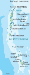
Andaman and Nicobar Islands
- The ‘Andaman and Nicobar’ islands are located in the ‘Bay of Bengal’. It is made up of about 572 small and big islands.
- Mainly these islands are parts of submerged mountains in the sea. The origin of some islands is also associated with volcanic activity.
- 10o North Latitude (10o Channel) separates Andaman Island from Nicobar Island.
- Andaman is a group of the following islands :- North Andaman , Middle Andaman , South Andaman, Little Andaman
- The capital of Andaman and Nicobar is located on Andaman Island. The famous ‘Cellular Jail’ is located here.
- ‘Coco Strait’ is located to the north of ‘Andaman (North Andaman)’, which separates Andaman from the ‘Coco Islands’ of Myanmar.
- ‘Duncan Pass’ is found between South Andaman and Little Andaman
- ‘Barren Island’ is located to the east of ‘Middle Andaman’, which is India’s only ‘active volcano’, while ‘Narcondam’ located to the east of North Andaman is a dormant volcanic island.
- Nicobar is also a group of many islands, such as :- Car Nicobar , Little Nicobar ,Great Nicobar.
- 6 degree channel separates Great Nicobar from Sumatra.
- Great Nicobar Island is geographically the closest Indian territory to Indonesia’s Sumatra Island.
- India’s southernmost point is ‘Indira Point’, which is located south of ‘Great Nicobar’. (It has submerged in water due to the 2004 tsunami).
- Another name of Indira Point is ‘Pygmalion Point’.
- The highest peak of Andaman and Nicobar Islands is ‘Saddle Peak’, which is located in North Andaman and ‘Mount Thullier’ is the second highest mountain peak of Andaman and Nicobar which is located on ‘Great Nicobar Island’.
- People of major tribes like ‘Jarawa’, ‘Shompen’, ‘Sentinelese’ etc. still live in their primitive state here.
- The Shompen tribe voted for the first time in the 16th Lok Sabha elections of 2014
Lakshadweep Group
- Lakshadweep is an island group formed by coral reefs in the Arabian Sea. The total number of islands here is 36, out of which only 10 are inhabited.
- Kavaratti is the capital of Lakshadweep which is located north of the ‘9o Channel’.
- ‘9° Channel’ separates Minicoy from the other islands of Lakshadweep (main Lakshadweep).
- ‘Minicoy’ (in other sources) is the largest island of Lakshadweep.
- ‘8° Channel’ separates Lakshadweep (Minicoy) from the Maldives.
Other Islands
Sriharikota
- This is an island located on the coast of Andhra Pradesh.
- India’s only satellite launch center ‘Satish Dhawan Space Center’ is located on this island.
- Sriharikota separates ‘Pulicat Lake’ from the Bay of Bengal. Pulicat Lake is located on the borders of Andhra Pradesh and Tamil Nadu.
Pamban Island
- It is a part of ‘Adam Bridge’ or ‘Ram Setu’ and is located between India and Sri Lanka
- ‘Rameshwaram’ is situated on the Pamban Island
- It is located in the Gulf of Mannar.
New Moore Island
- It is located on the border of India and Bangladesh in the Bay of Bengal, due to which
it has been divided between the two countries due to the dispute over its rights.
• Most of the part of this island which is in India’s part is submerged.
Abdul Kalam Island (Wheeler Island)
- It is an island located off the coast of Odisha and about 150 km from the capital Bhubaneswar.
- Its old name was ‘Wheeler Island’.
- India uses it as a testing center for its missile program.
Majuli Island
- Majuli Island is the largest river island in the world, situated in the middle of the Brahmaputra River in Assam. It is famous for its biodiversity.
- The population here is dense.
- Majuli has been declared the 33rd district of Assam. With this, it has become the country’s ‘first river island district.
Coastline of India
- The Indian coastline which is 7516.6 km long covers 6100 km of mainland coastline along with the Andaman, Nicobar and the Lakshadweep islands.
- The coastline of India touches 13 states and Union Territories.
- The Bay of Bengal and the Arabian sea came into being during the cretaceous or early tertiary period after the disintegration of Gondwanaland.
Important lakes of India
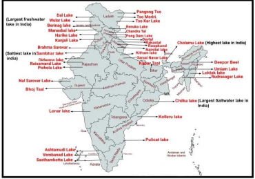
| Lake | Place | Type |
| Kolleru Lake | Andhra Pradesh | Natural freshwater |
| Sambhar Lake | Rajasthan | Saline |
| Dhebar Lake | Rajasthan | Artificial freshwater |
| Pushkar Lake | Rajasthan | Artificial freshwater |
| Pichola Lake | Rajasthan | Artificial freshwater |
| Rangsagar Lake | Rajasthan | Artificial lake |
| Govind Sagar Lake | Himachal Pradesh | Freshwater |
| Kanwar Lake | Bihar | Natural freshwater |
| Ashtamudi Lake | Kerala | Freshwater |
| Paravur Lake | Kerala | Saline Backwaters |
| Sasthamkotta Lake | Kerala | Freshwater |
| Bhojtal Lake | Madhya Pradesh | natural freshwater |
| Veeranam Lake | Tamil Nadu | natural freshwater |
| Chembarambakkam Lake | Tamil Nadu | artificial lake |
| Vaitarna Lake | Maharashtra | natural freshwater |
| Lonar Lake | Maharashtra | Freshwater |
| Vihar Lake | Maharashtra | natural freshwater |
| Dal Lake | Jammu and Kashmir | natural freshwater |
| Deepor Bill Lake | Assam | natural freshwater |
| Hussain Sagar | Telangana | artificial lake |
| Shamirpet Lake | Telangana | artificial lake |
| Sukhna Lake | Chandigarh | artificial freshwater |
| Tsomgo Lake | Sikkim | Freshwater (glacial) lake |
| Nainital Lake | Uttarakhand | Natural freshwater |
| Bhimtal Lake | Uttarakhand | Natural freshwater |
| Dodital | Uttarakhand | Freshwater lake |
| Senchal Lake | West Bengal | Artificial lake |
| Bela Sagar Lake | Uttar Pradesh | Artificial lake |
| Kanjia Lake | Odisha | Natural lake |
| Kanjali Wetland | Punjab | Freshwater lake |