- When the water of rivers flows through certain waterways (channels), it is called ‘drainage’ of the rivers and the network of these channels is called ‘drainage system’.
- The drainage system is an integrated system of the main river and its tributaries, which collects surface water and gives it direction.The Drainage Pattern means the ‘geometrical forms’ of the drainage systems and spatial arrangement of streams in particular locality or region.
- The area drained by a river and its tributaries is called ‘drainage basin’.
- A river brings its water from a specific area, which is called ‘catchment’ area.
Drainage Pattern of Rivers
→ Geological time period → Nature and structure of rocks
→ Topography → Slope gradient
→ Amount of water → Duration of flow
- Rivers have various patterns of drainage. Which are given below:-
- Dendritic
- The most common and widespread pattern resembles the branches, roots and rootlets of a tree.
- It is associated with areas of homogenous lithologies, horizontal and very gently sloping strata and areas of extremely low reliefs.
- Uniform lithology presents the most ideal condition for its development.

B.Meshed Drainage Pattern
- This pattern is formed by a system of tributary and main streams that flow down slopes and conform to geological structures.
- Such patterns develop in areas where there is simple folding, characterized by parallel anticlinal mountain peaks or parallel anticline valleys.
- Usually formed in cuesta topography, where harder layers become slopes and softer surfaces are eroded to form valleys and lowlands.
C.Rectangular
- Shows some degree of resemblance to the trellis pattern as both have tributaries joining master streams at right angles. But in trellis confluence is guided by strikes and dip angles of rock beds while in Rectangular pattern it is guided by lines of weakness.
- The second line of difference is that in trellis the spacing between the streams joining the mainstream is less than that of rectangular pattern.

d ) Trellis drainage pattern
- Formed by a network of tributaries and master consequent streams which follow the regional slope and are well adjusted to the geological structures.
- Developed in an area of simple folds characterised by parallel anticlinal ridges alternated by parallel synclinal valleys.
- Generally formed in cuesta topography where hard beds become escarpments and soft ones are eroded to become valleys and lowlands.
e)Radial or Centrifugal
- It is formed by streams which diverge from a central higher point in all directions.
- Domes, volcanic cones, residual hills etc. aid in its development.
- These streams resemble the spokes of the wheels.
- E.g: entire drainage network of Sri Lanka, South Koel, Subarnarekha rivers of Odisha and Jharkhand.

f) Centripetal or Inland
- It is opposite of the inland drainage pattern because it is characterised by streams which converge at a point; generally, a depression or a basin.
- Kathmandu valley sees tributaries of Bagmati converge.

g) Annular or Circular
- Formed when tributaries of master consequent are developed in the form of Circle.
- It is formed over mature and dissected domal mountains characterised by a series of alternate bands of soft and hard rock beds.
- Master consequent streams emerge at top and radiate in all directions.
- E.g. Sonapet dome of Bihar

h) Barbed
- Rare pattern formed when tributaries flow in opposite directions to the master streams.
- The tributaries join the main streams in hook shaped bends.
- Generally developed due to river capture
- Herringbone or Rib
- Developed in mountainous areas where broad valleys are flanked by parallel ridges with steep hillside slopes.
- The name comes from Herring fish. Upper Jhelum in the valley of Kashmir is an example.
- E.g. Basins of Mahanadi, Krishna, Cauvery Rivers etc.
Drainage System of Indian Rivers
- India is blessed with hundreds of large and small rivers which serve as a great source of water for irrigation, industry and domestic purposes. Almost all fertile lands in India have been formed by depositional work of rivers.
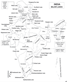
| Based on Size | Major river basins-20,000 SQ KM and more Medium basins- 2000 to 20,000 SQ Km Minor river basins- less than 2000 SQ km |
| Based on Orientation to the Sea | Bay of Bengal drainage Arabian sea drainage |
| Based on Origin | Himalayan river system Peninsular river system |
- The Himalayan River System
- The rivers originating from the Himalayas are perennial, that is, the flow of water in them remains continuous throughout the year, because they get water from both ‘melting of snow’ and rainfall.
- In their mountainous route, these rivers form deep gorges, V-shaped valleys, rapids and waterfalls and on reaching the plains, they form flat valleys, oxbow lakes, flood plains, meanders and deltas.
- The drainage system of the rivers originating from the Himalayas mainly includes the drainage system of three rivers-
(i) Indus River Drainage System
(ii) Ganga River Drainage System
(iii)Brahmaputra river drainage system
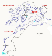
(i) Indus River Drainage System
- It rises near lake ManSarovar in Tibet from the glaciers of Kailas ranges. It enters India and continues to flow NW between Ladakh and Zanskar ranges. and enters India near ‘Demchok’ and while flowing through Ladakh and Gilgit, it forms a gorge and enters Pakistan near Chilas in Dardistan. Its length in India is 1114 km. and total length is 2,880 km.
- It encircles the town of Leh and is joined by Zanskar river and later by Shyok river.
- Many tributaries join the Indus river from both the left and right sides. Such as Shyok, Gilgit, Swat, Kabul, Zaskar, Panchnad (Jhelum, Chenab, Ravi, Beas, Sutlej) etc. Apart from Kabul, the other main tributaries found on the right bank are Kurram, Tochi, Gomal and Hunza. All these rivers originate from the Suleman mountain range.
- The Kabul River meets the Indus River near Attock Hills in Afghanistan.
- The Panchanad rivers join together and merge into the Indus River near ‘Mithankot’ in Pakistan.
- Indus empties into the Arabian Sea south of Karachi before forming a delta.
- Water of Indus is shared by India and Pakistan as per the Indus Water Treaty according to which, India can utilise only 20% of its total discharge.
1)Jhelum River
- It originates from ‘a spring at Verinag at the foot of the situated in Pirpanjal and flows through Wular Lake and meets Chenab River near ‘Jhang’ in Pakistan. It forms a meander near Srinagar.
- ‘Mangla Dam’ has been constructed on Jhelum River before it meets Chenab in Pakistan.
- Tulbul and Uri projects are being run on Jhelum River in Jammu and Kashmir.
2)Chenab River
- It is the largest tributary of Indus (length 1,180 km in India). In Himachal Pradesh it is known as ‘Chandrabhaga’.
- Chenab river is formed by the confluence of rivers named ‘Chandra’ and ‘Bhaga’ originating from both sides of Baralacha La pass at Tandi near Keylong.
- Important water projects constructed on Chenab River are Baglihar project, Salal project and Dulhasti project.
3)Ravi River
- It originates from the west of Rohtang Pass of the Greater Himalayas in Himachal Pradesh. It flows in the Chamba valley.
- The projects constructed on the Ravi River are ‘Chamera’ and ‘Thein’ (Ranjit Sagar) and the Shahpur Kandi Dam Project is proposed.
4)Beas River
- It enters the plains at a place called Talwara in Hoshiarpur district of Punjab.
- It meets Sutlej at a place called Harike and ‘Harike Barrage’ has been constructed at their meeting point.
- ‘Indira Gandhi Canal’ (India’s longest canal) has been constructed from Harike Barrage for the purpose of irrigation.
- It is the only river of Panchnad which flows only in India.
5)Sutlej River
- The Sutlej River also flows through the India-Pakistan border from Ferozepur to Fazilka (Punjab).
- The total length of the Sutlej River is 1,450 km. Out of which it flows in Indian territory for 1,050 km.
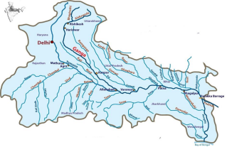
(ii) The Ganga River System
- Alaknanda originating from Satopanth Glacier and Bhagirathi originating from Gangotri Glacier near Gomukh are collectively known as Ganga after meeting at Devprayag.
- Tributaries of Alaknanda, such as ‘Pindar River’ joins it from the left bank at ‘Karnprayag’ and Mandakini River joins it from the right bank at ‘Rudraprayag’. Dhauli Ganga and Vishnuganga are other tributaries of Alaknanda. The famous temple of Badrinath is situated on the banks of Alaknanda River.
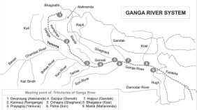
Ganga River System
- In fact, the Ganga river is the combined form of Bhagirathi and Alaknanda rivers, which join near Devprayag and are collectively called Ganga. The main source of the Ganga river is the Gangotri glacier located in Uttarakhand. It enters the plains near Haridwar. The Yamuna river joins it from the right side near Prayag (Allahabad). The river that joins the Ganga coming from the southern plateau is Son. Further, the Damodar river joins it after collecting water from the Chota Nagpur plateau. Small rivers like Punpun and Tons also join it from the right side. The main tributaries of the left bank of the Ganga are as follows from west to east – Ramganga, Gomti, Ghaghra, Gandak, Kosi, Budhi Gandak, Bagmati and Mahananda. The maximum length of the Ganga river is in Uttar Pradesh.
- After Farakka, the Ganga river flows towards the south-east and enters Bangladesh and is called Padma. From here, the Ganga divides into many streams and flows towards the south in the delta plain and meets the sea. In this part, it is known as Bhagirathi-Hooghly.
- Before Pawna, near Goludon, Brahmaputra (which is known as Yamuna here) meets Padma and their combined stream moves forward in the name of Padma. Meghna joins it near Chandpur and thereafter it divides into many water distributaries under the name of Meghna and meets the Bay of Bengal.
- The Ganga-Brahmaputra delta is considered to be the largest delta in the world, which is spread between the Hooghly and Meghna rivers. The sea part of the delta is covered with dense forests. Due to the abundance of Sundari tree, it is called Sundarvan. Hooglyis called the world’s most treacherous river. Kolkata port is situated on its banks, which is called the London of the East.
1. Ramganga River-
- This river is a relatively small river originating from the Garhwal hills situated in the Kumaon Himalayas near Gairsain.
- The origin of this river is a glacier. Therefore, there is a huge difference in the amount of water in this river during the rainy season and the dry season.
- After crossing the Shivalik, this river makes its way towards the south-west direction and enters the plains near Najibabad in Uttar Pradesh. Finally it joins the Ganga river near Kannauj. This river is 600 km. long and its drainage area is 32,800 sq. km.
2. Sharda (Saryu) River –
- This river originates from the Milam glacier in the Nepal Himalayas under the name Gori-Ganga, which is known as Kali River on the India-Nepal border. When it meets the Ghaghara river in Brahmaghat in Bahraich district of Uttar Pradesh.
3. Gandak River –
- It originates from Nepal Himalayas between Dhaulagiri and Everest Mountains. It brings water from the central part of Nepal, which enters the Ganges plain in Champaran district of Bihar and meets Ganga at Sonpur near Patna.
- This river is famous for its changing course. Its total length is 425 km and its drainage is spread over an area of 48,500 sq. km. (9,540 sq. km. in India).
4. Kosi River –
- It is one of the biggest tributaries of Ganga, which is a antecedent river. It is formed by the confluence of seven rivers. Its main stream Arun originates from Tibet (Fangchu) north of Mount Everest.
- As soon as it crosses the middle Himalayas in Nepal, Sunkoshi joins it from the west and Tamur Kosi from the east. After meeting Arun, it becomes Sapta Kosi.
- This river is 730 km long and its drainage area is 46,900 sq km, out of which 21,500 sq km is in India. Due to its tendency to change its course frequently, it is called the sorrow of Bihar.
5. Mahananda River –
- This river originates from the Darjeeling hills in West Bengal and merges with the Ganga near Siliguri making a sharp curve. In India, it is the last tributary of the Ganga on its left and northern bank. A famous canal has been drawn from it.
6. Ken-Karnavati River
- It originates from the Kaimur hills situated in Jabalpur district of Madhya Pradesh and meets Yamuna near Banda. Sonar and Bawas are its major tributaries. Chitrakoot is situated on the banks of this river.
7. Son River –
- This river originates from near the origin of Narmada in Amarkantak plateau situated in Madhya Pradesh, which is a tributary of Ganga on its right bank, west of Patna.
- This river originates from the plateau in the form of a series of waterfalls and meets the Kaimur range, which turns its course towards north-east. Gold particles are found in its sand, hence it is also called Golden River.
- It is 780 km long and the area of its drainage system is 54,000 sq. km. Its main tributaries are Kanhar, Rihand and Northern Koel.
8. Damodar River –
- This is a river flowing in the rift valley in West Bengal and Jharkhand. It originates from the eastern part of Chhota Nagpur plateau of Jharkhand and enters the delta plain of West Bengal near Asansol. Finally, it merges with the Hooghly river after receiving the water of Rupnarayan river.
- Its total length is 541 miles. The drainage area of this river is 22,000 sq. km. In the past, this river used to flood suddenly due to which it was called the sorrow of Bengal.
- India’s major coal and mica areas are located in this valley. Barakar, Jamunia and Barki are its major tributaries.
9. Yamuna River –
- It is the longest and westernmost tributary of Ganga. It originates from Yamunotri glacier (Tehri-Garhwal district) situated on the western slope of Badarpoonch.
- It flows parallel to Ganga and meets Ganga at Prayag (Allahabad). Tons river joins it behind Mussoorie range in the Himalayas towards the north. After this it moves forward cutting through the hills of small Himalayas, where Giri river joins it from the west and Asan river from the east.
- Chambal, Sindh, Betwa, Ken and Tons rivers also join it. All these originate from Aravali range (Rajasthan), Vindhya range and Malwa plateau of Madhya Pradesh. The length of Yamuna is 1,370 km. The area of its drainage area is 3,59,000 sq. km.
10. Chambal River –
- It originates from the Malwa plateau near Mhow in Madhya Pradesh, first flows through a gorge in the north direction up to Kota in Rajasthan, then passes through Bundi, Sawai Madhopur and Dholpur and finally joins the Yamuna near Etawah.
- It is famous for its rugged land. The rugged land is called ravines here. Its total length is 965 km. It is the only perennial river of Rajasthan. Its mythological name was Charmavati (Charmanvati). Banas, Mej, Parvati, Kali-Sindh and Kshipra are its tributaries.
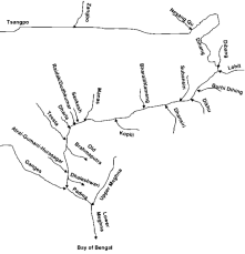
(iii) Brahmaputra river system
- Brahmaputra River (2,900 km) is one of the longest rivers of the world and in terms of total volume of water discharge, it is included among the four largest rivers of the world.
- Its drainage system is spread over three countries – Tibet (China), India and Bangladesh, whose drainage area is spread over an area of 5,80,080 sq. km. In India, it flows over a length of 1,346 km and its drainage area is 3,40,000 sq. km.
- It originates from Angsi Glacier near Mansarovar Lake, south of the Kailash mountain range. The basin of this river is separated from Mansarovar Lake by Marian La Pass. Most of the route of Brahmaputra is in Tibet, where its local name is Sangpo (Yarlung),which means – purifier.
- Here, it rises at an altitude of 4,000 m above sea level. Boats can ply even at an altitude of , which is one of the most amazing navigable waterways in the world.
- Taking a sharp turn along the eastern edge of the Namcha Barwa mountain, it turns to the south-west direction and forms a 5,500 m deep canyon.
- In Arunachal Pradesh it is called Dihang. Near Pasighat (near Sadiya) it is named Brahmaputra after its two tributaries Dibang and Lohit join it. After this it enters the Assam valley where many tributaries join the Brahmaputra.
- Among these, Subansiri, Jia Bhareli, Dhanshri, Puthimari and Manas are the main ones. It flows westwards till Dhubri city and then turns southwards from Garo Hills and enters Bangladesh near Goalpara. In Bangladesh, its name is Jamuna. Here, rivers like Teesta etc. join the Brahmaputra and finally merge with the Padma (Ganga).
- The main stream of Meghna, Barak River, originates from the hills of Manipur. Its main tributaries are Maku, Tarang, Tuivai, Jiri, Sonai, Rukni, Katakhal, Dhaleshwari, Langchinni, Maduwa and Jatinga. Barak River continues to flow in Bangladesh until it merges with the Ganges-Brahmaputra River near Bhairav Bazar.
- In the Assam valley, the Brahmaputra river forms a braided waterway in which some large river islands are also found. These include the world’s largest river island Majuli. This island is in a critical condition and efforts are being made to preserve it and include it in the World Heritage List. In the year 2016, it was declared an island district of India.
2. The Peninsular Drainage System
- These have existed for much longer than the Himalayan rivers and thus have reached a mature stage.
- They have eroded almost up to their base level.
- Characterised by broad, shallow, and largely braided valleys.
- The East flowing rivers form big deltas while the west flowing one’s form Estuaries.
- West flowing rivers, especially Narmada and Tapi flow through hard rocks and are not able to form distributaries before they enter the Sea.
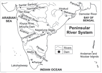
The East Flowing Rivers
1. The Mahanadi :-
- The Mahanadi basin extends over states of Chhattisgarh and Odisha and comparatively smaller portions of Jharkhand, Maharashtra and Madhya Pradesh.
- The Mahanadi has its source in the northern foothills of Dandakaranya in Raipur District of Chhattisgarh.
- It is bounded by the Central India hills on the north, by the Eastern Ghats on the south and east and by the Maikal range on the west.
- The Mahanadi is one of the major rivers of the peninsular rivers, in water potential and flood producing capacity, it ranks second to the Godavari.
- Other small streams draining directly into the Chilka Lake also form part of the Mahanadi basin.
- At Sambalpur, the Hirakud Dam (one of the largest dams in India) on the river has formed a human-made lake 35 miles (55 km) long.
- It enters the Odisha plains near Cuttack and enters the Bay of Bengal at False Point by several channels.
- Tributaries :–
- Left bank Tributaries: Seonath, Hasdeo, Mand and Ib etc.
- Right bank Tributaries: Ong, Tel and Jonk etc.
2. The Godavari:
- Emerges near Trimbak plateau of Nashik in Maharashtra.
- The Godavari basin extends over states of Maharashtra, Telangana, Andhra Pradesh, Chhattisgarh and Odisha in addition to smaller parts in MP, Karnataka and Union territory of Puducherry (Yanam).
- Largest system of the peninsula and the river is also referred to as Vridha Ganga or Dakshin Ganga.
- Below Rajahmundry, it divides itself into two streams :- Gomati , Godavari and Vashishta .Godavari before forming a delta and falling into the Bay of Bengal.
- Tributaries:
- Left Bank tributaries are :- Wardha, Wainganga, Pranhita, Penganga, Wainganga, Sabari.
- Right bank tributaries :- Manjra River is the only important one and it joins Godavari after passing through Nizam Sagar.
3. The Krishna:
- Second largest east flowing river of the Peninsula.
- The Krishna Basin extends over Maharashtra, Telangana, Andhra Pradesh and Karnataka.
- Rises in the Western Ghats, just north of Mahabaleshwar and flows into the Bay of Bengal
- Tributaries:
- Left bank tributaries :- Bhima, Musi (Hyderabad located on its banks), Munneru etc.
- Right bank tributaries :- Ghatprabha, Koyna, Malprabha, Tungabhadra (largest) etc.
- Important dams on this river include Nagarjuna Sagar, SriSailam, Almatti etc.
- It forms a large delta which appears to merge with that of Godavari.
4. The Cauvery:
- Rises in the Brahmagiri range, Kodagu (Coorg) district of Karnataka.
- The Cauvery basin extends over states of Tamil Nadu, Karnataka, Kerala and Union Territory of Puducherry.
- Its upper catchment area receives rain by SW monsoon during summer and the lower catchment area receives rain by NE monsoon during winter.
- Therefore, it is almost a perennial river and is useful in power generation and irrigation.
- The river descends from the South Karnataka Plateau to the Tamil Nadu Plains through the Shivasamudram waterfalls (101 m high).
- At Hogenakkal Falls, it takes Southerly direction and enters the Mettur Reservoir.
- In the last stage, the river divides into two parts, the Northern branch being called the Coleroon and Southern branch remains as Cauvery, and from here the Cauvery Delta begins.
- After flowing for about 16 km, the two branches join again to form Srirangam Island.
- Tributaries:
- Left bank tributaries :- Harangi, Hemavati, Shimsha and Arkavati etc.
- Right bank tributaries :- Lakshmantirtha, Kabbani, Bhavani, Noyil and Amravati etc.
5. The Subarnarekha :-
- Originates from the Ranchi Plateau in Jharkhand forming the boundary between West Bengal and Odisha in its lower course before joining the Bay of Bengal.
- It forms an estuary between the Ganga and Mahanadi deltas.
6. The Brahmani:
- The Brahmani (800 km) comes into existence by the confluence of the Koel and the Shankh rivers near Rourkela, Odisha.
- The basin is surrounded by the Chota Nagpur plateau and the Mahanadi basin.
- The basin flows through Jharkhand, Chhattisgarh and Orissa drains into the Bay of Bengal.
7. The Penner:
- Rises in the Chenna Kesava hill of the Nandidurga range, in Chikkaballapura district of Karnataka and flows towards east eventually draining into the Bay of Bengal.
- Its basin extends over states of Andhra Pradesh and Karnataka.
- Seshachalam Hills (famous for Red Sanders) and Paliconda ranges are important hill ranges in the basin.
- Tributaries:
- Left bank tributaries: Jayamangali, Kunderu and Sagileru etc.
- Right bank tributaries: Chiravati and Papagni etc.
The West Flowing Rivers
1. The Narmada:
It is the largest of all west flowing rivers of peninsular India.
It rises from the western flanks of Amarkantak in MP.
Flows westward in a rift valley between the Vindhyas and the Satpuras.
It forms famous falls: Dhuandhar Falls (known as Marble Falls) near Jabalpur, Kapildhara Falls near Amarkantak and Sahastradhara Falls near Maheshwar, both in Madhya Pradesh.
It meanders through alluvial plains past Bharuch (GJ) and forms an Estuary before falling into the Gulf of Khambhat.
There are several riverine islands in Narmada’s estuary- Aliabet is the largest.
Major hydropower projects in the basin include Indira Sagar, Sardar Sarovar, Omkareshwar, Barg
and Maheshwar etc.
Left bank Tributaries: Tawa.
Right bank tributaries: Hiran, Kolar etc.
2. The Tapi or Tapti:
Also known as twin or handmaid of Narmada, it originates from Satpura in Betul district of MP.
Second largest west flowing river in peninsular India.
Flows through Khandesh plains of Maharashtra between Satpuras and Ajanta ranges.
It makes an estuary near Surat and falls into the Gulf of Khambhat.
Left bank Tributaries: Purna, Patki etc.
Right bank tributaries: Girna, Amravati etc
3. The Sabarmati :-
- The Sabarmati is the name given to the combined streams of the Sabar and Hathmati.
- The Sabarmati basin extends over states of Rajasthan and Gujarat.
- The total length of the river from origin in Aravalli Hills (Rajasthan) to outfall into the Arabian Sea is371 km.
- Industrial city of Ahmedabad is located on its banks.
- It falls in the Gulf of Khambhat.
4. The Mahi
- The Mahi basin extends over states of Madhya Pradesh, Rajasthan and Gujarat.
- It originates from the northern slopes of Vindhyas in Dhar district of Madhya Pradesh and drains into the Gulf of Khambhat.
- Hydro Power stations are located in MahiBajaj Sagar dam and at Kadana Dam.
- It crosses the Tropic of Cancer twice.
5. The Luni or Salt River
- Names so as its water is brackish below Baltora.
- It originates in the Pushkar valley of the Aravalli Range, near Ajmer, passes through the south-eastern portion of the Thar Desert, and ends in the marshy lands of Rann of Kutch in Gujarat, after travelling a distance of 495 km.
- Water of the Luni River is brackish after Balotra (Rajasthan) where high salt content in the soil impacts the river.
- Luni is the only river basin of any significance in Western Rajasthan, which forms the bulk of the arid Zone.
| Difference between Himalayan river system and Peninsular river system | |
| Himalayan River System | Peninsular River System |
| They have large basins and catchment areas. | They have small basins and small catchment areas. |
| The Himalayan rivers flow through deep I-shaped valleys called gorges, which have been cut downstream by the rivers along the uplift of the Himalayas. | Peninsular rivers flow through shallow valleys as compared to Himalayan rivers and are completely graded. |
| These rivers are examples of retrograde drainage. | Peninsular rivers are an example of successional drainage and these rivers do very little erosion. |
| They are perennial in nature and receive water from both monsoon and snow-fed feeders. | Water comes in these rivers due to rainfall and hence these rivers are seasonal, not perennial. |
| They flow through young fold mountains and are still in their youthful stage. | Flowing on old plateaus, these rivers have attained a mature stage. |
| Turbulence is observed in their lower reaches. | Due to hard and strong rocks, these rivers are neither able to move here and there nor create water distributaries. |
| They form large deltas near their mouths. The Ganges Brahmaputra delta is the largest in the world. | Rivers flowing in the east form deltas but rivers flowing in the west form estuary deltas. |
HYDRO POWER PROJECTS
- Dams are constructed across rivers to create reservoirs where water for irrigation and other purposes is stored.
- The potential energy of the water stored in reservoirs can be tapped to generate electric power in hydel power projects.
- India ranks fourth after China, USA and Russia in terms of number of dams.
- Tehri dam on Bhagirathi river (Uttarakhand) is the tallest dam in India (260 m) and also the eighth highest dam in the world.
- Hirakud dam on Mahanadi river (Odisha) is the longest dam in India.
- Indira Sagar Project on Narmada river (Madhya Pradesh) has the largest reservoir in terms of storage of water
| Important Falls and their location | |
| Falls | Location/Significance |
| Sahastradhara Falls | Two falls with the same name. One on Narmada River in Maheshwar (MP). Other is a limestone formation near Dehradun |
| Elephanta Falls | Near Shillong, Meghalaya. |
| Chuliya Falls | On Chambal near Kota (Rajasthan). |
| Dhuandhar Falls | On Narmada near Jabalpur (MP). |
| Rajrappa Falls | At the confluence of Damodar and Bhairavi in Jharkhand. |
| Duduma Falls | On Machkund River on the border of Odisha and Andhra Pradesh. |
| Kapildhara Falls | On Narmada near Amarkantak (MP) |
| Hundru Falls | On Subarnarekha near Ranchi |
| Dudhsagar Falls | On the Mandovi River in Goa |
| Gokak Falls | On Gokak River in Karnataka |
| Shivasamudram Falls | On Kaveri near Bangalore (Karnataka). |
| Nohkalikai Falls | Near Cherrapunji, Meghalaya. One of the tallest falls in India. |