
- Climate is the aggregate of the atmospheric condition involving heat, Moisture and air movement.
- The climate of India is described as the Tropical type monsoon indicating the impact of its location in the tropical belt and the monsoon wind.
- On-going and future vegetative changes, sea level rise and inundation of India’s low-lying coastal areas are attributed to global warming.
- Although a sizable part of the country lying north of the Tropic of Cancer falls in the northern temperate zone, the shutting effects of the Himalayas and the existence of the Indian Ocean in the south have played significant roles in giving India a distinctive climatic characteristic.
FEATURES OF THE INDIAN CLIMATE
| Reversal of winds | Reversal of wind system with the change of season in a year.During the Winter season wind generally blows from north- east to south west direction and in Summer season, it completely reverses. |
| Seasonal and Spatial Variation of rainfall | 80% annual rainfall is obtained in the latter part of the summer whose duration lasts from 1-5 months.Spatial variation ranges from 12 cm to more than 250 cm in a year. |
| Diversity of Indian Climate | These are caused by Difference in the location, altitude, distance from the sea and General reliefs condition at different places.Impact of High and Low pressure over the landDue to the low temperature, a high pressure area is formed and vice versa.Ex- intense heating of the land in summer season to formation of the thermally induced low pressure cell over the north western part of the country. |
FACTORS AFFECTING INDIAN CLIMATE
- India climate controlled by the number of factors but which can be divided into two group :
1. Factor related to location and Relief.
2. Factors related to Air pressure and wind.
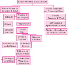
Factors Related to Location and Relief
| Latitude and Altitude | Almost half of the country, lying south of the Tropic of Cancer, belongs to the tropical area. All the remaining area, north of the Tropic, lies in the sub-tropics. Therefore, India’s climate has characteristics of tropical as well as subtropical climates. In the factor of Altitude, Temperature decreases with height. Due to the thin air, places in the mountains are cooler than places on the plains. |
| Distance from the Sea | Oceans heat up and cool down much more slowly than land. This means that coastal locations tend to be cooler in summer and warmer in winter than places inland at the same latitude and altitude. |
| Distribution of land and water | The differential heating of land and sea creates different air pressure zones in different seasons in and around the Indian subcontinent |
| The Himalayan Mountains | Prevent the cold winds from Central Asia from entering the subcontinent. Thus, the subcontinent experiences comparatively milder winters as compared to central Asia. |
- Factor Related to Air Pressure and Wind
- Air pressure and wind systems are different at different altitudes. Following factors impact on the local climate of india.
- Surface pressure and wind
- Jet stream and upper air circulation
- Western cyclonic disturbance and Tropical cyclone
- These factor have different mechanism with reference to winter and summer season of the yearly separately:
- Weather condition in winter season
- Weather condition in summer season
WEATHER CONDITION IN WINTER SEASON
- Surface Pressure and Wind
- During the northern hemisphere’s winter, High pressure area is built in Central and west Asia. This centre of high pressure gives rise to the flow of air at the low level from the north towards the Indian subcontinent.
- These continental winds come in contact with trade winds over northwestern india.
- Now, the contact zone is not stable and sometimes it shifts up to the middle Ganga valley thus bringing the entire North-western India the influence of the North-Westerly winds.
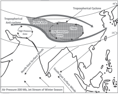
- Jet Stream and Upper Air Circulation
- During winters the Westerly Jet Streams positioned in Asia are bifurcated due to the Tibetan Himalayas.
- The Northern branch blows north of the Himalayas and Tibetan Plateau and brings rain (Western Disturbances) to western part of India (Southern branch- south of the mountains).
- Western Cyclonic Disturbance and Tropical Cyclone
- Western cyclonic disturbances are weather phenomena of the winter months brought in by the Westerly flow from the Mediterranean region. Usually influences the weather of the north and north-western regions of India and brings little rain in the winter month which is good for the wheat crops.
- Tropical cyclones occur during the monsoon as well as in October-November, and are part of the easterly flow. These disturbances affect the coastal regions of the country. These tropical cyclones have very high wind velocity and heavy rainfall and hit the Tamil Nadu, Andhra Pradesh and Orissa coast.
WEATHER CONDITION IN SUMMER SEASON
- Surface Pressure and Wind
- In summer, the northward shift of the Sun leads to shifting of the ITCZ northwards in the month of july. So, this time, the westerly jet stream withdraws from the Indian region.
The impact of northward shift of ITCZ
- It’s a Low Pressure area zone, so ITCZ attracts winds from all around.A low-pressure area develops over interior Asia as well as over northwestern India.
- This causes a complete reversal of the direction of winds during summer. Air moves from the highpressure area over the southern Indian Ocean, in a south-easterly direction, crosses the equator, and turns right towards the low-pressure areas over the Indian subcontinent. These are known as the Southwest Monsoon windsz.
- These winds blow over the warm oceans, gather moisture and bring widespread rainfall over the mainland of India.
2.Jet Stream and Upper Air Circulation
- An easterly jet stream flows over the southern part of the Peninsula in June, and has a maximum speed of 90 km per hour in August;
- It is confined to 15°N, and in September up to 22 Degree North latitudes. The easterlies normally do not extend to the north of 30°N in the upper atmosphere.
Western Cyclonic Disturbance and Tropical Cyclone
- The easterly jet stream steers the tropical depressions into India. These depressions play a significant role in the distribution of monsoon rainfall over the Indian subcontinent.
- The tracks of these depressions are the areas of highest rainfall in India. The frequency at which these depressions visit India, their direction and intensity, all go a long way in determining the rainfall pattern during the southwest monsoon period.
Indian Monsoon
- India’s climate is of ‘warm monsoon’ type. However, it is worth noting that the northern part of India which is located north of the Tropic of Cancer comes under the temperate zone and the part located south of the Tropic of Cancer comes under the tropical zone.
- The Indian monsoon is mainly related to the changes in atmospheric circulation that occur during the summer season
- With the onset of summer, the Sun begins to move northwards. Along with the Sun’s movement northwards, the Inter Tropical Convergence Zone (ITCZ) also begins to move northwards. Due to its effect, the western jet stream starts flowing north of the Himalayas and due to the high temperature in the Indian subcontinent, low air pressure develops.
- After the western jet stream shifts to the north of the Himalayas, the ‘eastern jet stream’ develops in India. Its position varies according to the seasons in about 15°-30°north latitude, and it is considered to be primarily responsible for the Indian monsoon outbreak.
- Due to the influence of the eastern jet stream, high air pressure develops near the island of Madagascar in the southern Indian Ocean. The south-west monsoon originates from this high pressure centre.
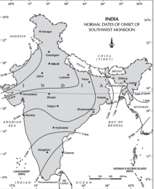
Arrival of Monsoon in India
- Monsoon rain in India is ‘seasonal’ and occurs during June to September.
- In the first week of June, monsoon winds reach the coastal areas of Kerala, Karnataka, Goa and Maharashtra. The monsoon winds first hit the coast of Kerala, which is called ‘monsoon burst’
Theories related to Origin of Indian Monsoon
- Thermal Theory or the Classical theory
- This theory was propounded by ‘Edmund Halley’ in 1656 to ‘explain the origin of Asian monsoon’.
- According to this theory, ‘monsoon’ is the result of thermal contrast generated due to difference in the heating of continents and oceans.
- In summer, the rays of the sun fall perpendicularly on the Tropic of Cancer, due to which a low pressure center develops here and the ‘thermal equator’ shifts towards the north. Due to this, the south-east trade winds are drawn towards the low pressure center and when these winds cross the equator, they turn to the right due to the effect of ‘Coriolis force’, where their direction becomes ‘south-west’.
- Since these winds travel a long distance in the sea, they also bring with them a sufficient amount of moisture. Due to which it causes rainfall in the Indian subcontinent. This is known as ‘South-West Monsoon Rain’.
- Unlike summer, in winter when the direct rays of the sun fall on the Tropic of Capricorn, the land part of Asia becomes colder than the oceans, due to which a center of high air pressure is formed on the land and a center of low air pressure develops in the region of the South Indian Ocean – as a result, winds start blowing from the land towards the ocean.
- Due to coming from the land, there is less moisture in these winds, due to which there is a lack of rainfall. But due to the Coriolis force, when these winds turn to their right and enter the Bay of Bengal, they absorb moisture from there and their direction becomes ‘north-east’, due to which there is rainfall on the coast of Tamil Nadu (Coromonddal coast). This is called ‘North-East Monsoon Rain’.
- According to critics, this is a simplified explanation of monsoon, because the northward and southward positions of the Sun remain fixed every year, whereas there is uncertainty in the arrival of monsoon.
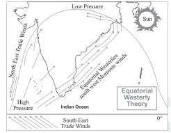
- Dynamic Concept or The Equatorial Westerlies Theory
- This theory was propounded by ‘Flon’. According to him, monsoon is the normal seasonal movement of ‘westerly winds’ according to the northward and southward movement of the Sun.
- According to this, due to the northward movement of the thermal equator in summer, the ‘Intertropical Convergence Zone’ (ITCZ) also shifts towards the north. As a result, the (equatorial) westerly winds start influencing the low pressure areas formed on the Indian subcontinent and ultimately the south-west monsoon originates.
- Tropical disturbances are seen to be active along the Northern Intertropical Convergence Zone (NITCZ). They play an important role in affecting the regional weather.
- In winter, when the Sun moves southward, the low pressure area changes into high pressure. As a result, the north-eastern trade winds again become effective.
- Jet Stream Theory
- It is a very fast air flow system in the upper atmosphere, which also affects the weather of the lower atmosphere.
- According to this theory, the ‘tropical eastern jet stream’ causes the origin of the ‘south-west monsoon’ in India and the ‘subtropical western jet stream’ helps in the origin of the ‘north-east monsoon’ (winter monsoon).
- In winter, the subtropical western jet stream flows from west to east throughout western and central Asia and when it reaches the Tibetan plateau, it gets divided into two branches due to obstruction.
- One branch starts flowing from the north of the Tibetan Plateau parallel to the plateau and the other branch moves eastward south of the Himalayas which brings ‘Western Disturbance’ to the Indian subcontinent in winter.
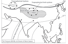
- In summer (at the time of the northward movement of the Sun) all the temperature zones get displaced towards the north, due to which the ‘subtropical western jet stream’ also gets displaced towards the north of the Tibetan plateau. Due to this, the effect of ‘tropical eastern jet stream’ is produced in the upper atmosphere of the Indian subcontinent.
- Tropical eastern jet stream is a type of regional and seasonal jet stream. It originates from the center of high air pressure developed in the upper layers of the troposphere due to the ascent of hot air (air getting heated and rising) due to high temperature on the Tibetan plateau during summer.
- The wind blowing from the center of high air pressure towards the South Indian Ocean through the Bay of Bengal and the Arabian Sea is called ‘tropical eastern jet stream’.
- Due to this jet stream, high air pressure develops due to the descent of air near the island of Madagascar. When the south-eastern trade winds blowing from here cross the equator, they turn to the right due to the Coriolis force and hit the coast of the Indian subcontinent and cause rain. These are known as the ‘South-West Monsoon’.
ORIGIN OF INDIAN MONSOON
- Indian Monsoon depends on the Differential heating of sea and land but alone it can’t produce the Monsoon circulation.
- Role of Jet Stream
- The burst of monsoons depends upon the upper air circulation which is dominated by SubTropical Jet Streams (STJ). The south west monsoon coming in India is related to tropical easterly stream. It blows between 8 degree- 35 degree North latitudes.
- The north east monsoon (winter monsoon) is related to the subtropical westerly Jet Stream which blows between 20 degree and 35 degree latitudes in both hemispheres.
B. Role of the Himalayas and Tibetan Plateau
- Tibet plateau plays a crucial role in initiating the monsoon circulation. Due to its enormous height it receives 2-3 Degree Celsius more insolation than the neighbouring areas.
- Heating of these areas leads to a clockwise air circulation in the middle troposphere and two-wind streams originate from this area. One of these wind streams blow southward and develop into the tropical easterly jet stream (TEJ).
- The other stream blows in an opposite direction towards the North Pole and becomes the westerly jet stream over Central Asia.
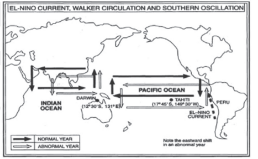
C. El Nino and Indian Monsoon
- El-Nino is a complex weather system, which appears every five or ten years. It causes drought, floods and extreme weather conditions in different parts of the world.
- The literal meaning of El-Nino is ‘Child Jesus’, because this current appears in the month of December around Christmas. December is the summer month in Peru (Southern Hemisphere).
- El-Nino is used for long-term forecasting of monsoon in India. A severe form of El-Nino was seen in 1990-91. Due to this, the arrival of monsoon was delayed by 5 to 12 days in most parts of the country.
- This system involves oceanic and atmospheric phenomena. In the eastern Pacific Ocean, it appears as a warm sea current near the coast of Peru. This affects the weather of many places including India. El Niño is merely an extension of the equatorial warm ocean current, which temporarily replaces the cold Peruvian or Humboldt current. This current increases the temperature of the water off the Peruvian coast by 10°C. It has the following consequences:
- Distortion in the equatorial atmospheric circulation;
- Irregularities in the evaporation of sea water;
- Decrease in the amount of plankton, which leads to a decrease in the number of fish in the sea.
D. Role of Walker Cell
- The Walker circulation is the result of a difference in surface pressure and temperature over the western and eastern tropical Pacific Ocean.
- A pressure gradient from east to west creates an air circulation from the Eastern pacific i.e. along the coast of Peru-Chile to western Pacific (Australia-New Guinea).
- Walker cell is associated with southern oscillationand its strength fluctuates with that of the Southern Oscillation Index (SOI).
E. Indian Ocean Dipole and Indian Monsoon
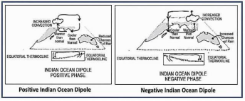
- In case of positive Indian Ocean Dipole, the temperature of tropical western Indian Ocean (Arabian Sea) is higher than the normal temperature of eastern Indian Ocean. Positive Indian Ocean Dipole creates favourable conditions for Indian Monsoon.
- In case of negative Indian Ocean Dipole, the temperature of tropical western Indian Ocean is lower than normal and the temperature of tropical eastern Indian Ocean is higher than normal. Negative Indian Ocean Dipole creates unfavourable conditions for Indian Monsoon.
NATURE AND IMPORTANT ASPECTS OF MONSOON
- Systematic studies of the causes of rainfall in the South Asian region help to understand the causes and salient features of the monsoon, particularly some of its important aspects, such as:
- The onset of the monsoon.
- Rain-bearing systems (e.g. tropical cyclones) and the relationship between their frequency and distribution of monsoon rainfall.
- Arabian Sea Branch and Bay of Bengal Branch.
- Break in the monsoon.
- Retreat in Monsoon.
The Onset of Monsoon
- Differential heating of land and sea during the summer months is the mechanism which sets the stage for the monsoon winds to drift towards the subcontinent.
- During April and May when the sun shines vertically over the Tropic of Cancer, the large landmass in the north of the Indian Ocean gets intensely heated. This causes the formation of an intense low pressure in the north-western part of the subcontinent. So low pressure cells attract the southeast trade winds across the equator.
- The shift in the position of the ITCZ is also related to the phenomenon of the withdrawal of the westerly jet stream from its position over the north Indian plain, south of the Himalayas. The easterly jet streamsets in along 15°N latitude only after the western jet stream has withdrawn itself from the region. This easterly jet stream is held responsible for the burst of the monsoon in India.
Rain Bearing Systems
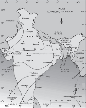
- The southwest monsoon splits into two branches, the Arabian Sea Branch and the Bay of Bengal Branch near the southernmost end of the Indian Peninsula.
- First originated in the Bay of Bengal causing rainfall over the plains of north India. Second is the Arabian Sea current of the southwest monsoon which brings rain to the west coast of India. The latter extends toward a low-pressure area over the Thar Desert and is roughly three times stronger than the Bay of Bengal branch.
Arabian Sea Branch
- The Arabian Sea branch of the southwest monsoons is divided into three distinct streams on arriving in the mainland of India.
- The first stream strikes the west coast of India and gives extremely heavy rainfall of over 250 cm. It strikes perpendicular to Western Ghats causing plentiful Orographic Rainfall (400 to 500 cm annual rainfall on the windward side).
- Rainfall is drastically reduced to about 30-50 cm on the leeward side of the crest. There is a narrow belt of marked aridity on the immediate leeward side of the Western Ghats. But once it is passed, the air starts rising again and the amount of rainfall increases further east.
- The second stream enters Narmada – Tapi troughs (narrow rift valley) and reaches central India. It does not cause much rain near the coast due to the absence of major orographic obstacles across the rift. Some parts of central India receive rainfall from this stream (Ex: Nagpur).
- The third stream moves parallel to the Aravalli Range without causing much rainfall. Consequently, the whole of Rajasthan is a desert area.
- However, some orographic effect is occurring on the south-eastern edge of the Aravalli Range. Mt. Abu gets about 170 cm rainfall while the surrounding plains have only 60 to 80 cm rainfall.
Bay of Bengal Branch
- The first stream crosses the Ganga – Brahmaputra delta and reaches Meghalaya. Here the orographic effect results in intense rainfall. Cherrapunji receives an annual rainfall of 1,102 cm, major portion of which occurs from June to August.
- Mawsynram, located at 1,329 m above sea level just 16 km to the west of Cherrapunji, records higher annual rainfall of 1,221 cm. Both the stations are located on the southern slopes of the Khasi hills at the northern end of a deep valley running from south to north.
- The second stream: of the Bay of Bengal branch moves along Himalayan foothills as they are deflected to the west by the Himalaya and brings widespread rainfall to Ganga plain.
- The rainfall by this stream is characterised by a steady decline as we move from east to west up the plain. The Tamil Nadu coast remains relatively dry during the south-west monsoon period because of:
- Rain shadow effect of the Arabian Sea current and
- Bay of Bengal current which flows parallel to the coast
Break in the Monsoon
- During the south-west monsoon period after having rains for a few days, if rain fails to occur for one or more weeks, it is known as break in the monsoon. These dry spells are quite common during the rainy season.
- These breaks in the different regions are due to different reasons:
- In northern India rains are likely to fail if the rainbearing storms are not very frequent along the monsoon trough or the ITCZ over this region.
- Over the west coast the dry spells are associated with days when winds blow parallel to the coast.
Retreat in Monsoon
- retreating means withdrawal. So, withdrawal of south-west monsoon winds from skies of north India during months of October and November is known as retreating monsoon. The withdrawal is a gradual process and takes about three months.
Seasons
- The climate of India is mainly divided into 4 seasons-
1. Summer (15 March to 15 June)
2. Rainy season (15 June to 15 September)
3. Autumn (15 September to 15 December)
4. Winter (15 December to 15 March)
Summer Season
- With the displacement of the sun rays towards the Tropic of Cancer in March, the temperature in North India starts increasing, due to which summer season is clearly experienced in North India in the months of April, May and June. During the summer season, the temperature in most parts of India is found to be around 30° to 32° Celsius. Whereas in the month of May, due to the shifting of the heat belt towards the north, it is normal for the temperature of the north-western parts to reach 48° Celsius.
- In India, due to the northward movement of the vertical rays of the sun between March and June, there is an increase in temperature and decrease in pressure, along with which the temperature zones also get displaced towards the Indian subcontinent, due to which the ‘subtropical western jet stream’ also gets displaced from the northern plains of India towards the Himalayas. As a result, due to high temperature in the north-western states of India, a center of low air pressure develops. The hot or dry winds blowing in the centre of this low pressure before the arrival of the southwest monsoon winds are called ‘loo’ in Rajasthan, Uttar Pradesh and Bihar. During this time, heavy rain-laden storms named Kal Baisakhi, Bodoi Chila and Norwester blow in West Bengal, Assam and Odisha respectively
Some famous local storms that occur during summer
- Mango Showers :- Pre-monsoon showers occur towards the end of summer, which are common in Kerala and coastal Karnataka. Locally, this stormy rain is called ‘Mango Showers’ because it helps mangoes to ripen early
- Flower Showers :- This rain causes the blooming of Kahwa flowers in Kerala and the nearby Kahwa producing areas.
- Kaal Vaishakhi :- These are fierce and destructive rain-bearing winds that blow in the evenings of the month of Vaishakh in Assam and West Bengal. Their notorious nature can be gauged from their local name Kaal Baisakhi, which means devastation in the month of Vaishakh. These winds are good for tea, jute and rice. In Assam, these storms are called ‘Bordoichila’.
Annual cycle of seasons in India
- India’s climatic conditions can best be described in terms of the annual cycle of seasons. Meteorologists recognize the following four seasons:-
1. Winter
2. Summer
3. South-west monsoon season
4. Retreating monsoon season
- Weather is a characteristic of the Indian climate. Temperature, pressure, wind direction and the amount and duration of rainfall vary from season to season.
| winter season | |
| Duration | Mid November to February. |
| General Properties | Clear skies, pleasant weather, low temperatures, low humidity, high temperatures, cool and north-easterly trade winds.Diurnal range of temperatures is very high, especially in the interior parts of the country. |
| Temperature | The 20°C isotherm runs almost parallel to the Tropic of Cancer. Kerala and parts of Tamil Nadu usually have temperatures close to 30°C.The average minimum temperature is about 5°C in north-west India and 10°C in the Gangetic plains. |
| Wind Turbulence | High pressure over northwestern India.Winds blow from northwest to southeast.Disturbances are brought by jet winds |
| Rain | The retreating winter monsoon crossing the Bay of Bengal picks up some moisture and causes winter rains over Tamil Nadu, south Andhra Pradesh, southeast Karnataka and southeast Kerala (usually in the first weeks of November). Northwest India also receives some rainfall due to western disturbances. |
| Warm seasonal season | |
| Duration | April May June. |
| General Characteristics | High temperature and low humidity are its main characteristics.Also seen in the form of dust storms and dryness |
| Temperature | In March, the highest temperatures occur in the southern parts (40-45°C).In April the highest temperatures of about 45°C are recorded in the northern parts of Madhya Pradesh.In May the highest temperature shifts to Rajasthan where temperatures can be recorded as high as 48°C.The diurnal range of temperature is also very high. It may exceed 18°C in some parts. |
| Wind Turbulence | Low pressure over northwestern part of India and high pressure over southern parts of Bay of Bengal.ITCZ shifts to Gangetic plain.Wind direction varies from one part of India to another. Dust storms are frequently experienced during afternoon hours in northern plains. |
| Rainfall | Overall dry season.Dust storms and thunderstorms provide some rainfall.Eastern regions receive comparatively more rainfall. |
| Southwest monsoon season | |
| Duration | June-September |
| General Characteristics | Sudden onset is an important feature of the southwest monsoon.Temperature drops drastically and humidity levels increase. |
| Temperature | Temperatures remain fairly constant throughout the rainy season.Temperatures rise with the end of the southwest monsoon in September.Temperatures in other parts of northwest India also remain above 30°C. |
| Wind Turbulence | Due to low pressure over the northwestern part of India and high pressure over the southern parts of the Bay of Bengal, the ITCZ shifts to the Gangetic plain. The wind direction varies from one part of India to another. The northern plains experience dust storms during the afternoon |
| Rainfal | The average rainfall in the plains of India is about 87 percent during this season.The progress of the monsoon is much faster in the Bay of Bengal than in the Arabian Sea.The monsoon advances rapidly with thunder, lightning and heavy rain |
| Retreating Monsoon Season | |
| Duration | October-November |
| General Characteristics | The monsoon winds are gradually retreating and the temperature rises abruptly with the heat of October.Unlike the southwest monsoon, the onset of the north monsoon is not clearly defined. |
| Temperature | With the withdrawal of monsoon, clouds disappear and the sky becomes clear.Day temperatures start falling rapidly.The diurnal range of temperature increases due to lack of cloud cover. |
| Wind Turbulence | The direction of winds over large parts of the country is influenced by local pressure conditions. |
| Rainfall | October – November is the main rainy season in the south of the Krishna delta and adjoining areas of Tamil Nadu and Andhra Pradesh as well as Kerala receives normal rainfall at this time.While passing over the Bay of Bengal, the retreating monsoon absorbs moisture and causes rainfall. |
CHARACTERISTICS OF MONSOON RAINFALL
- Seasonal in nature
- Uneven distribution
- Distance from sea
- Dependency of agriculture on monsoon
- Depends upon topography
- Heavy rainfall
DISTRIBUTION OF RAINFALL
- Mostly influenced by the relief features on the surface of the Earth and the direction of the rain-bearing winds in that region.
- Another important factor is the path followed by the cyclonic depressions.
- The region located on the windward side of mountains, hills or plateaus receives comparatively more rainfall than the leeward side.
- Broadly, India can be divided into the following four regions, depending upon the average annual rainfall received by those regions.
| Heavy Rainfall (more than 200 cm) | Khasi and Jaintia Hills (more than 1000 cm) and Brahmaputra valley.This region does not experience drought conditions, but is subjected to frequent floods. |
| Moderate Rainfall (100-200 cm) | Eastern slopes of the Western Ghats, northern and middle Ganga valley, north-eastern peninsula, Manipur, coastal areas of Andhra Pradesh and Tamil Nadu.Irrigation is needed as a protective measure against drought. |
| Low Rainfall (50-100 cm) | Upper Ganga Valley, eastern Rajasthan, Punjab, Haryajia, Kashmir and large parts of Gujarat, Maharashtra, Western Madhya Pradesh, Andhra Pradesh, Karnataka, and Tamil Nadu.Large irrigation projects have been developed to overcome the danger of droughts and famines. |
| Inadequate Rainfall(Less than 50 cm) | The rain-shadow areas in the Deccan Plateau, north Kashmir, southern Punjab, western Rajasthan and Kachchh.There is an acute shortage of water in these areas. |
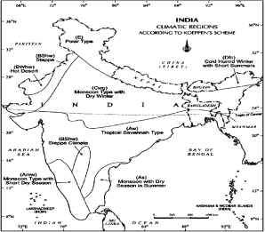
Climatic Regions of India
- While classifying Indian climatic zones, most geographers have given more importance to rainfall than temperature because the variation in rainfall is much greater than that in temperature.
| Five Major Climates (Koppen) | |
| Climate Classification | Climatic zones |
| Monsoon type with short dry season (Amw) | The western coastal region which lies south of Goa experiences this type of climate. |
| Monsoon type with dry season in summers (AS) | The region of this type of climate extends along the Coromandel coast. |
| Tropical Savanna type (Aw) | Almost the entire peninsular region except for some coastal parts experiences this type of climate. |
| Semi-arid steppe climate (BShw) | This climatic region includes the interior parts of the Peninsular Plateau and some parts of Gujarat, Rajasthan, Haryana, Punjab and Jammu and Kashmir. |
| Hot desert (BWhw) | This type of climate is found only in the western part of Rajasthan. |
| Monsoon type with dry winter season (Cwg) | Most of the northern plains of India experience this type of climate. |
| Climate region with short hot and cold winter wet season (Dfc) | This climate is characterised by a short summer season. This region covers the north-eastern parts of India. |
| Polar type (E) | This type of climate is experienced in Jammu and Kashmir and neighbouring mountain ranges. |
FLOODS IN INDIA
- Flood is a state of high-water level along a river channel or on the coast that leads to inundation of land. India is highly vulnerable to floods.
- Out of the total geographical area of 329 million hectares, Rashtriya Barh Ayog (RBA) has assessed that more than 40 million hectare area is flood prone.
| Causes | Natural CausesHeavy rainfall, Sediment deposition, Cyclones, Changes in course of river, Tsunami.Anthropogenic CausesDeforestation, Interference in drainage system, Population pressure, Poor sewage management. |
| Remedies | Structural Measures Dams, reservoirs and other water storages Flood walls, embankments Drainage improvements Diversion of flood water AfforestationNon-Structural Measures Flood forecasting and warning, Integrated water resource management, Flood management plans. |
DROUGHTS IN INDIA
- Droughts refer to a serious shortfall in availability of water, mainly, but not exclusively, due to deficiency of rains, affecting agriculture, drinking water supply and industry.
- It is a slow onset disaster which evolves over months or even years and affects a large spatial extent.
| Meteorological Drought | Due to inadequate rainfall. |
| Agricultural Drought | Due to low soil moisture available for crops. |
| Hydrological Drought | Due to availability of different water storages falls below what precipitation can replenish. |
| Ecological Drought | When productivity of the ecosystem falls due to absence of water. |