- Earth has two important parts- oceans and continents. Oceans (hydrosphere) cover 70.8% of the Earth and continents (lithosphere) cover 29.2%. The northern hemisphere has more landmass than the southern hemisphere. It is believed that the continents are still moving away from each other.
Continental Drift Theory (Alfred Wegener), 1912
- The famous German scholar Alfred Wegener presented this theory in the year 1912. He found that a geographical uniformity can be given by combining the present continents.
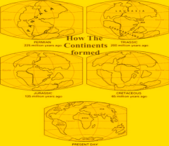
- In the Carboniferous era, all the landmasses of the earth were connected to each other. He named this big continent as Pangea. There was a huge ocean around it which was called Panthalassa.
- In the last Jurassic period, the division of Pangaea began and one part of it moved towards the north and the other part towards the south.
- The northern part was called Laurasia (Angaraland) and the southern part was called Gondwanaland. A shallow and narrow ocean was formed between these two land parts which is called Tethys Sea.
- Around 6.5 crore years ago in the late Cretaceous era, as a result of the disintegration of Gondwanaland, South America, Africa, Peninsular India, Madagascar and Australia were formed.
- Angaraland separated and formed North America, Europe and Asia. Due to the displacement of both America towards the west, the Atlantic Ocean was formed.
Forces of Drifting
- Pole Fleeing Force: Due to rotation of Earth
- Tidal Force: Due to the attraction of the moon and the sun.
Evidence
- Matching of Continents – Jigsaw Fit
- Rocks of same age across the oceans
- Tillite ( Sedimentary rocks found out of deposits of glaciers)
- Placer deposits: Similar in Ghana Coast and Coast of Brazil
- Distribution of Fossils: Occurrence of lemurs across India, Madagascar And Africa.
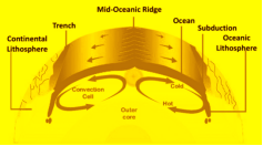
Sea Floor Spreading (Hess), 1961
- It was proposed by Harry Hess in 1961.
- Volcanic eruptions are common and they bring huge amounts of lava to the surface in the area of Mid Oceanic ridges.
- The rocks on either side of the crest of mid oceanic ridges show remarkable similarities like age, chemical composition and magnetic properties.
- The ocean crust rocks (200 million years old) are much younger than the continental rocks (3200 million years old).
- The sediments on the ocean floor are unexpectedly very thin.
- The deep trenches have deep seated earthquake occurrences while in mid oceanic ridges, the quake foci have shallow depths.
Plate Tectonic Theory
- This theory was propounded by Tujo wilson in 1965.
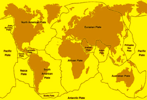
- According to this theory, the earth’s crust is divided into many small and large plates.
- These plates are made up of lithosphere of 100 km thickness and float on the asthenosphere which is completely made up of sima and has relatively higher density.
- The main reason for plate movement is the cyclic transmission process of thermal convection waves due to the presence of radioactive substances in the asthenosphere.
- Till now only six large and 20 small plates have been identified.
- The six large plates are as follows- 1. American Plate 2. African plate 3. Eurasian plate 4. Indo-Australian Plate 5. Pacific plate 6. Antarctica plate
- Among the smaller plates, Nazca Plate (Eastern Pacific Plate), Cocos Plate, Arabian Plate, Philippine Plate, Scotia Plate and Caribbean Plate, Juan-de-Fuca Plate, Somali Plate, Burmese Plate etc. are important.
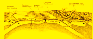
- The edges of the plates are most important from the point of view of geological activities because seismic, volcanic and tectonic events occur along these edges. Generally, the edges of the plates are divided into three types-
| Type of Plate Margin | Constructive/Divergent Boundary | Destructive/Convergent Boundary | Conservative/Transform Boundary |
| Motion | Diverge | Converge | Slide |
| Topography | Ridge/rift | Trench | Faults |
| Volcanic Activity | yes | Yes | No |
1. Constructive Margin
- These are located above the upward columns of thermal convective waves. Due to this, two plates move in opposite directions to each other and a fault crack develops between them, with the help of which the magma of the asthenosphere comes up and solidifies to form a new earth’s crust.
- Hence, these plate edges are called constructive margins (Diverging Margin) and such plates are called divergent plates.
2. Destructive Margin
- These are located above the downward columns of thermal convective waves. Due to this, two plates converge and collide with each other. In this process, the plate of higher density gets subducted below the plate of lesser density. This area is called the Belt of Zone. Since the destruction of the plate takes place here, hence it is called the destructive edge.
3. Conservation Margin
- When two plates move parallel to each other, there is no interaction between them, hence it is called a conservative edge. Here a transform fault is formed, for example the San Andreas fault formed near California.
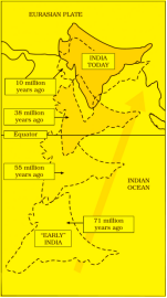
Indian Plate
- India was a large island situated off the Australian coast. The Tethys Sea separated it from the Asian continent till about 225 million years ago.
- About 200 million years ago Peninsular India started its journey towards the north.
- India collided with Asia about 40-50 million years ago causing rapid uplift of the Himalayas.
- The process is continuing, and the height of the Himalayas is rising even to this date.
- The northward movement of the Indian tectonic plate pushing slowly against the Asiatic plate is evident by the frequent earthquakes in the region.
- During the movement of the Indian plate towards the Asiatic plate, a major event that occurred was the outpouring of lava and formation of the Deccan Traps (shield volcano).