
INTRODUCTION
- Water is present in the atmosphere in three forms namely gaseous, liquid and solid.
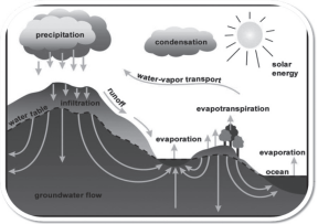
- The moisture in the atmosphere is derived from water bodies through evaporation and from plants through transpiration.
- Evaporation :- a process by which water is transformed from liquid to gaseous state.
a. Latent Heat of Vaporization: Heat required to change one unit of liquid to gaseous state.
b. Evaporation affected by: temperature, movement of air, the moisture content in the air.
- Transpiration :- a process by which water absorbed by roots of plants evaporates from leaves and flowers due to Sunlight/heat.
- Sublimation is the conversion between the solid and the gaseous phases of matter, with no intermediate liquid stage.
Humidity
- The amount of water vapour present in the air is called ‘humidity’. The proportion of water vapour in the atmosphere is found to be between 0 to 4 percent, i.e., their proportion also changes with change in location.
- The process by which water turns into water vapour is called ‘evaporation’. Maximum evaporation takes place on continents in 10° south latitudes. Maximum evaporation takes place on continents. Maximum evaporation takes place on oceans. Maximum evaporation takes place on continents. Maximum evaporation takes place on oceans between 10°-20° latitudes in both the hemispheres.
Types of Humidity
Absolute Humidity
- The amount of water vapor present per unit volume of air is called ‘absolute humidity’. Generally it is measured in ‘grams per cubic meter’.
Absolute humidity is higher near the equator and decreases as we move towards the poles.
- Absolute humidity is higher at sea level and decreases as the distance from the sea increases.
- The possibility of rainfall depends on the amount of absolute humidity.
Specific Humidity
- The total mass of water vapour present in gram units in one kilogram of humid air is called ‘specific humidity’. Specific humidity indicates the actual amount of moisture present in a fixed volume of humid air.
- ‘Specific humidity’ is directly related to the amount of vapour pressure i.e. if the vapour pressure increases, the specific humidity also decreases if the vapour pressure decreases.
Relative Humidity
- The ratio of the ‘amount of water vapour’ and ‘capacity to hold water’ present in the air at a given temperature is called ‘relative humidity’. In other words, the ratio of the moisture capacity (capacity to hold excess moisture) of a fixed volume of air at a given temperature and the actual amount of moisture present in it (absolute humidity) is called ‘relative humidity’.
- Relative humidity is expressed in percentage.
- When the relative humidity becomes 100 percent, the air becomes saturated and the point at which the air becomes saturated is called the ‘dew point’. At the dew point, water vapor turns into ‘water/snow’ through condensation.
CONDENSATION AND PRECIPITATION
- The amount of water vapour in the atmosphere is added or withdrawn due to evaporation and condensation respectively.
- The transformation of water vapour into water is called condensation. (the reverse of evaporation)
- Condensation is caused by the loss of heat.
- In free air, condensation results from cooling around tiny particles known as hygroscopic condensation nuclei. Ex: dust, smoke and salt.
- It is influenced by the volume of air, temperature, pressure and humidity.
- Condensation takes place :-
- When the temperature of the air is reduced to dew point with its constant volume.
- When both the volume and the temperature are reduced.
- When moisture is added to the air.
- After the condensation of water vapour, the release of moisture is known as Precipitation, which may take place in the form of liquid (rainfall) or solid (snowfall).
| Dew | When atmospheric moisture does not condense on condensation nuclei in the air above the surface but gets deposited on solid objects like stones, grass and leaves etc. in the form of water droplets, then it is called ‘dew’.Dew is formed only when the following conditions or conditions are present simultaneously – the sky is clear; the air is calm; there is high relative humidity; there are cold and long nights; the dew point is above the freezing point. |
| Dew Point | The temperature at which the air becomes saturated, i.e. the temperature at which the capacity of a fixed volume of air to hold moisture at a given time and the absolute humidity present in it become equal, is called the ‘dew point’. |
| Freezing Point | The temperature at which a liquid changes into a solid. For example, the freezing point of pure water is 0°C or 32°F. |
| Frost | Formed on cold surfaces when condensation takes place below freezing point. |
| Fog & Mist | Fog is a cloud with its base at or very near to the ground.Mist is a form of fog but it contains more moisture than fog. Because of the fog and mist, the visibility becomes poor to zero. |
| Sleet | Frozen raindrops and refrozen melted snow-water. When a layer of air with the temperature above freezing point overlies a sub freezing layer near the ground, precipitation takes place in the form of sleet. |
| Hailstones | Solid form of precipitation.Formed when drops of water freeze together in the cold upper regions of thunderstorm clouds. |
CLOUDS
- Cloud is a mass of floating water droplets or tiny crystals of ice.
- Formed by the condensation of the water vapour in free air at considerable elevations.
- According to their height, expanse, density and transparency or opaqueness clouds are grouped under four types :-
Based on the Height of Clouds
| High clouds | Medium cloud | Low cloud |
| (Average height 6-20 km) | (2.5 – 6 km) | (Upto 2.5 km) |
| Cirrus clouds Cirrostratus cloudsCirrocumulus clouds | AltrostratusAltocumulus clouds | Stratocumuls cloudsStratus cloudsNimbostratus cloudsCumulus cloudsCumulonimus clouds |
| Types of clouds | Features |
| Cirrus | Formed at high altitudes (8,000-12,000 m).Thin and detached clouds having a feathery appearance.Aways white and composed of ice crystals Before sunrise and after sunset, cirrus is often coloured bright yellow or redThese clouds are lit up long before other clouds and fade out much later. |
| (Cirrostratus Clouds) | These clouds are spread like a wide sheet of milky colour. Due to these clouds, a ‘halo’ is formed around the sun and the moon. |
| (Cirrocumulus Clouds) | These clouds are in the form of small, white, circular clusters. These clouds are also called ‘Mackerel Sky’. |
| (Altocumulus Clouds) | These clouds are blue/grey in colour and there are higher chances of rain. |
| high level clouds (Altostratus Clouds) | These clouds are found in the form of wavy currents. Due to vertical air currents, these clouds develop upwards. Rainbow hues are visible in them. Such clouds formed on mountain peaks are called ‘Banner Clouds’. |
| Stratocumulus Clouds | These low-altitude clouds are light brown in colour. These clouds without rain are an indicator of clear weather. |
| (Stratus Clouds) | These clouds spread at a very low height from the surface of the earth and cover the sky like fog. They are usually formed when two winds of opposite nature meet each other. |
| rain stratum cloud (Nimbostratus Clouds) | These clouds appear to stand like huge towers from the bottom up and are spread over a wide area. Due to their density, darkness prevails. |
| Cumulonimbus Cloud (Cumulus Clouds) | Their shape is like a ‘cauliflower’ and these clouds look like a pile of cotton. Generally these clouds are rainless, sometimes they also become thunder clouds.These clouds have the highest vertical expansion. Heavy downpours, hailstorms and lightning storms originate from these clouds. In tropical cyclones, rain mainly occurs from these clouds with the help of cold fronts. |
Rainfall
- When the process of condensation continues rapidly, small droplets of water combine to form larger droplets and fall on the earth’s surface. These freely falling water droplets are called ‘rain’.
- The size of the droplets in rain can be from about 0.5 millimeters to 7 millimeters. Generally, rain occurs from clouds located at comparatively high altitudes.
TYPES OF RAINFALL
- Based on origin, rainfall may be classified into three main types, the conventional, orographic or relief and the cyclonic or frontal.
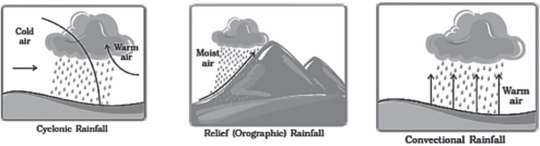
1 . Conventional Rains
- Rising warm and light convection currents expands and loses heat and consequently, condensation takes place and cumulus clouds are formed.
- Heavy rainfall with lightning and thunder takes place which does not last long.
- Common in the summer or the hotter part of the day.
- The equatorial regions and interior parts of the continents, particularly in the Northern hemisphere receive this type of rainfall.
- Orographic Rainfall
- When the air ascends along the mountain slope due to a mountain obstruction in the path of moist air, the air cools down as it rises. As a result, rain occurs due to the process of condensation. This type of rain is called ‘mountain rain’.
3.Cyclonic Rainfall
- When the warm air rises on the ‘front’ formed by the convergence of warm and cold air, it starts expanding. As a result, the air gets cold and finally rain is obtained by the process of condensation. This type of rain is called ‘cyclonic rain’ or ‘frontal rain’.
WORLD DISTRIBUTION OF RAINFALL
- Different places on the earth’s surface receive different amounts of rainfall in a year and that too in different seasons.
- In general, as we proceed from the equator towards the poles, rainfall goes on decreasing steadily
| Heavy Rainfall(greater than200 cm annually) | The equatorial region The coastal region under monsoon Windward side of coastal mountains |
| Moderate Rainfall (between 100 to 200 cm annually) | Adjacent regions of very heavy rainfall areasCoastal regions in the warm temperate region |
| Inadequate Rainfall (between 50 to100 cm annually) | Eastern part of the continents in temperate regions. Interior of continents in tropical regions |
| Low Rainfall(less than 50 cm annually) | Rain shadow regions The western part of continents in tropical Regions |
| Extremely low rainfall (less than 25 cm annually) | Hot and cold deserts |