Atmospheric Pressure
- The weight of the column of air at a given place and time. In this barometer, it is measured as the weight per unit area.
- Rapid fall in the reading of the barometer indicates stormy weather.
- The first fall and then gradual rise of the reading of the barometer indicates rainy conditions.
- Continuous rise of mercury in the barometer indicates anti-cyclonic and clear weather.
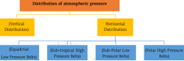
1. Vertical Distribution – The air density and atmospheric pressure are higher in the lower layers of the atmosphere. Air pressure decreases with height. Although there is no direct relationship between
height and air pressure, the average rate of decrease in air pressure in the troposphere is about 34 millibars per 300 meters of height.
2. Horizontal distribution – The latitudinal distribution of atmospheric pressure is called the horizontal distribution of air pressure. Its main feature is its regional character due to which air pressure zones and belts are formed.
Factors Responsible for Variation
- High temperature leads to rise of air, hence low pressure and vice versa.
- The Earth’s rotation leads to rise of air at equator and fall in tropics; hence, equator has low pressurewhile tropics have high pressure.
- Air with a higher quantity of water vapour has lower pressure.
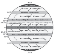
GLOBAL PRESSURE BELTS
(i) Equatorial low pressure belts (0-5° north and south latitudes) – This is a zone of extremely low air pressure. This is a thermally generated low pressure zone. In this zone, there is no horizontal surface wind, because the winds moving towards this zone get heated and start rising as soon as they reach its boundaries. As a result, only vertical air currents are found in this zone. Due to extremely calm atmospheric conditions, this zone is called the doldrums or calm zone.
(ii) Subtropical high pressure belts (30-35°) north and south latitudes – Along with thermal factors, dynamic factors are also responsible for its formation. The windsrising from the equatorial low pressure region flow towards the poles in the upper atmosphere. But due to the rotation force of the Earth, they start getting deflected towards the east. This force was first described by the French scientist Coriolis, hence this force was named Coriolis force.
- With increasing distance from the equator, the amount of this force also increases. As a result, by the time the wind moving towards the poles reaches 25° latitude, its direction has deflected so much that it starts flowing from west to east and starts acting as a barrier for the winds coming ahead. And due to increased weight, the wind starts descending there and a high pressure zone is formed between 30-35° north and south latitudes. Due to extremely weak and variable winds, the atmosphere remains very calm here.
- This pressure zone is also called the horse latitude, because in the olden times, boats carrying horses used to face a lot of difficulty due to the calm atmospheric conditions here and to lighten the weight of the boats, horses sometimes had to be thrown into the sea.
(iii) The Subpolar low Pressure Belts (near the North and South Poles)
- Extends between 45°N and the Arctic Circle (66.5°N) in the northern hemisphere and between 45°S and the Antarctic Circle (66.5°S) in the southern hemisphere.
- Winds coming from the subtropical and the polar high belts converge here to produce cyclonic storms or low pressure conditions.
- This zone of convergence is also known as the polar front.
(iv) The Polar High Pressure Belts (near the North and South Poles)
- Lie around poles between 80° – 90° N and S latitudes.
- In Polar Regions, Sun Rays are always slanting, resulting in low temperatures.
- Because of low temperature, air compresses and its density increases. Hence, high pressure is found here.
- Winds from these belts blow towards the subpolar low pressure belt.
Wind
- Due to horizontal differences in air pressure, air flows from high air pressure area to low air pressure area. This air moving horizontally is called wind. This is nature’s effort towards balancing the differences in air pressure.
- The air moving in a nearly vertical direction is called air current. Both wind and air currents together complete a cyclic process, in this context the example of Hadley cell can be taken.
- Due to the difference in circumference and rotation speed in different latitudes of the earth, the wind does not flow at right angles to the isobar lines in the direction directed by the pressure gradient but gets deflected in its original direction. This happens due to the effect of Coriolis force. As the speed of the wind increases, the amount of this force also increases. Its intensity increases towards the poles. Due to the effect of Coriolis force, the winds of the northern hemisphere get deflected towards their right and the winds of the southern hemisphere get deflected towards their left. Since this feature was proved by a French scientist named Ferrel, hence it is called Ferrel’s Law.
TYPES OF WIND
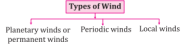
Planetary Winds
- The pattern of the movement of the planetary winds is called the general circulation of the atmosphere.
- Also sets in motion the ocean water circulationwhich influences the earth’s climate.
- Blow in the same direction throughout the year.
- There are 3 types of planetary wind :-
| Trade winds or easterlies or eastern winds | The winds which blow from the subtropical high pressure areas towards the equatorial low pressure areas are called trade winds or easterlies.Due to the Coriolis effect, the trade winds in the Northern Hemisphere blow away from the subtropical highs in the north-east direction (clockwise).In the Southern Hemisphere the trade winds turn from the subtropical highs to the south-east direction (anticlockwise) towards the equatorial lows.The trade winds blow mainly from the east, hence called tropical easterlies. |
| Westerly winds or Western winds (Westerlies) | Blows between about 35o and 65o north and south latitudes.In the Northern Hemisphere the winds moving polewards from the subtropical high pressure are deflected to the right and thus blow from the south-west.These are deflected to the left in the Southern Hemisphere and blow from the north-west direction. Hence these winds are called westerlies.The westerlies of the Southern Hemisphere are stronger due to the predominance of water (known as roaring forties, fierce fifties and screaming sixties) and are more consistent in direction due to the predominance of water. |
| Polar winds | Polar winds blow from the polar regions towards the subpolar low pressure areas.In the Northern Hemisphere from north-east to south-west.In the Southern Hemisphere from south-east to north-west. |
Seasonal Or Periodic Wind
- The winds whose direction changes according to the season or time are called seasonal winds. Monsoon winds, land breeze and sea breeze as well as mountain breeze and valley breeze are included in this category of winds.
| Monsoon Winds | All those winds on the surface whose direction changes completely according to the season are called monsoon winds. The first detailed discussion on this was done by the Arab geographer Al Masoodi. These winds blow from the sea towards the land for sixmonths in the summer season and from the land towards the sea for six months in the winter season. This happens due to the different tendency of land and water to get heated. They originate in the belt of trade winds between the Tropic of Cancer and the Tropic of Capricorn. The most ideal conditions for their origin are found in South and South-East Asia. |
| Land & Sea Breeze | Due to differential heating of land and water a pressure gradient is created causing Sea breeze during day and land breeze during nights. |
| Mountain and Valley Breezes | Due to differential heating of mountains and valleys a pressure gradient is created causing valley breeze during day and mountain breeze during nights. |
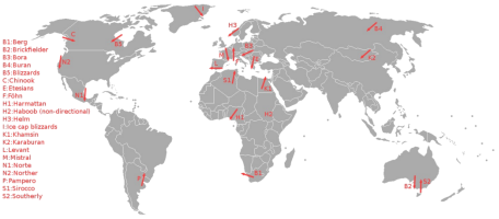
Local winds
- These winds blow due to local differences in temperature and air pressure and affect a very small area. While hot local winds increase the temperature of a particular region, cold local winds sometimes lower the temperature even below freezing point. Theselocal winds are confined to the lower layers of the troposphere. Some of the major local winds are as follows :-
| Chinook | It is a warm and dry wind blowing along the eastern slopes of the Rocky Mountains, which flows from the southern part of Colorado in the south to British Columbia in Canada in the north. Due to its effect, snow melts and green grass grows even in winter. |
| Fohn | Like Chinook, this is a warm and dry wind that descends from the northern slope of the Alps. It has the greatest impact in Switzerland. |
| Sirocco | This is a hot, dry and sand-filled wind that blows from the Sahara desertnorthwards through the Mediterranean Sea and enters Italy and Spain. Here, the rain caused by it is known as blood rain.The local names of Sirocco in Egypt, Libya, Tunisia are Khamsin, Ghibli, Chili. |
| Black Roller | These are hot and dusty dry winds blowing in the vast plains of North America. |
| Yoma | It is a hot and dry wind similar to Santana in Japan. |
| Simuk | Hot and dry wind blowing in the Arabian desert which causes sand storms and reduces visibility. |
| Samun | It is a local wind blowing in Kurdistan of Iran and Iraq which has similar characteristics as Fohn. |
| Shamal | It is a hot, dry and sandy wind blowing in the desert region of Iraq, Iran and Arabia. |
| Harmattan | It is a hot and dry wind blowing from north-east and east to west direction in the Sahara desert, which brings dryness in the hot and humid air of the western coast of Africa, due to which the weather becomes pleasant and healthy. Due to this reason, it is called doctor wind on the Guinea coast. |
| Brickfield | This is a hot and dry wind blowing in Victoria province of Australia. |
| Norwester | This is a hot and dry wind blowing in North New Zealand. |
| Loo | This is a strong and dry wind blowing from northwest and west to east in North India in summer, which is actually also called heat wave. |
| Santana | This is a hot and dry wind blowing in California. |
| Zonda | These are the axial dry winds blowing from Andes towards the plains in Argentina and Uruguay. It is also called cold fohn. |
| Mistral | These are cold polar winds which blow through the valley of the river Rhone and affect the north-western part of the Mediterranean Sea, especially Spain and France. With its arrival the temperature falls below freezing point. |
| Bora | Like the Mistral, this is also a dry and extremely cold wind and blows on the eastern shores of the Adriatic Sea. It mainly affects Italy and Yugoslavia. |
GEOSTROPHIC WINDS
- Because of the balancing of the Pressure Gradient Force by Coriolis force in the upper troposphere, winds flow parallel to the Isobars. These winds are called Geostrophic Winds.
- These winds can also form in a cyclonic or anticyclonic circulation.
- It is also the reason why the air rising from the equatorial belt does not go straight towards the pole but descends in the subtropics.
- One important type of geostrophic winds are the Jet Streams.
Jet Streams
- These are very fast horizontal winds blowing near the tropopause. Jet air currents are active in a transition belt about 150 km wide and 2 to 3 km thick.
- Jet streams are generally found in the Northern Hemisphere. In the Southern Hemisphere, they are found only over the South Pole, although in a mild form they are found over other latitudes as Rossby waves.
- Jet streams move from west to east. The main reason for the origin of these jet streams is the difference in temperature on the Earth’s surface and the air pressure gradient created by it.
Types of Jet streams
| Permanent Jet Streams | These jets exist throughout the year in mid and higher latitudes. Their strength and intensity varies with seasons. |
| Subtropical Jet Stream (STJ) | These winds flow between the Hadley and Ferrel cells. The STJ exists all year in the southern hemisphere. However, it is intermittent in the northern hemisphereduring summer when it migrates north. |
| Polar Front Jet Stream | This jet stream blows between the Ferrel and Polar cells. It has a more variable position than the subtropical jet.In summer, its position shifts towards the poles and in winter towards the Equator.They are stronger and more regular in winters. |
| Temporary Jet Streams | Also known as tropical jet streams because they occur over tropics. |
| Tropical Easterly Jet Stream | The TEJ is a unique and dominant feature of the northern hemisphere summer over southern Asia and northern Africa.The TEJ is found between 5° and 20°N. |
| Somali Jet Stream | The Somali jet occurs during the summer over northern Madagascar and off the coast of Somalia.The jet is most intense from June to August.It is a major cross-equatorial flow from the southern Indian Ocean to the central Arabian Sea. |
AIR MASS
- A large body of air having little horizontal variation in temperature and moisture is known as Air Mass.
Source Region
- When air remains over a homogenous area for a sufficiently longer time, it acquires the characteristics of the area. These are known as Source Regions
- It imparts heat and moisture characteristics to the overlying air mass.
- This can be the vast ocean surface or vast plains and plateaus.
- There are no major source regions in the mid latitudes as these regions are dominated by cyclonic and other disturbances.
Types of Air Mass
| Cold Air Mass | Air Mass which is colder than the underlying surface.Example, Air mass over Siberia is not cold for Siberia. This air mass might be cold air mass for the warmer regions down south. |
| Warm Air Mass | Air Mass which is warmer than the underlying surface.Example, The same air mass over Siberia might be warm air mass for the Arctic region. |
Cyclone
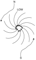
- These are centers of low air pressure around which there are isobar lines of gradually increasing air pressure. In a cyclone, the wind direction is from the periphery towards the center. Their direction is anticlockwise in the northern hemisphere and favorable in the southern hemisphere. Their shape is spherical, semi-spherical, oval or like the letter V. They have considerable importance in determining climate and weather. Wherever they reach, they affect the conditions of rainfall and temperature.
There are two types of cyclones-
- Temperate 2. Tropical
- Tropical Cyclones
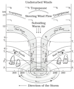
- Tropical cyclones are strong low pressure centres that originate over oceans in tropical areas and move over to the coastal areas bringing about large scale destruction due to violent winds, very heavy rainfall (torrential rainfall) and storm surge.
- A roughly circular area of comparatively light winds and fair weather found at the centre of a severe tropical cyclone is known as the Eye of the cyclone.
- The eye is the region of lowest surface pressure and warmest temperatures as air descends at the centre.
- The eye is surrounded by the eye wall, the roughly circular ring of deep convection, where winds blow the fastest.
- Tropical cyclones have a compact size, ranging from 80 km to 2000 km in diameter.
- Conditions for Development of Tropical Cyclones :-
- Large sea surface(Temperature >27◦C)
- Small variation in vertical wind speed
- Presence of coriolis force
- Upper divergene above sea level system
- Pre existing weak low pressure
- The latent heat of evaporation released by the condensation of moist rising air over oceans is the driving engine for tropical cyclones.
- These cyclones cannot sustain over land because the latent heat of evaporation is not available. Therefore, they dissipate after they make landfall.
- Tropical cyclonic systems move in a parabolic pathtowards the west. Then they get deflected by the Coriolis force.
- They are most commonly formed over :-
- South-east Caribbean region where they are called hurricanes.
- Philippines islands, eastern China and Japanwhere they are called typhoons.
- Bay of Bengal and Arabian Sea where they are called cyclones.
- Around the south-east African coast and Madagascar Mauritius islands.
- North-west Australia where they are known as Willy Willy.
- Wind circulation is anti-clockwise in the northern hemisphere and clockwise in the southern hemisphere.
- These cyclones can be predicted in advance.
- Temperate Cyclones
- The low pressure systems developing in the mid and high latitude , beyond the tropics are called the Temperate Cyclones or Extra Tropical Cyclones or Mid-Latitude Cyclones or Frontal Cyclones or Wave Cyclones.
- They are most commonly formed at the polar frontswhere warm and moist air masses meet cold and dry air masses from poles.
- The cold air pushes the warm air upwards from underneath. Thus a void is created because of lessening of pressure. The surrounding air rushed in to occupy this void and coupled with the Earth’s rotation, a cyclone is formed which advances with the westerlies (Jet Streams).
- These cyclones are actually the formation and occlusion of stationary, cold and warm fronts.
- The temperate cyclones occur mostly in winter, late autumn and spring.
- They are generally associated with rainstorms and cloudy weather.
- The temperate cyclones are asymmetrical and shaped like an inverted ‘V’.
- They stretch over large areas under the influence of westerlies.
- The approach of a temperate cyclone is marked by fall in temperature and pressure and a halo around the Sun and the moon, and a thin veil of cirrus clouds.
- Since these cyclones move with the westerlies (Jet Streams), they are oriented west-east.
- The western disturbances arriving in North West India during winters are remnants of such cyclones.
(Difference Between Temperate and Tropical Cyclones)
- Temperate cyclones occur between 35o and 65o latitudes while tropical cyclones develop between 5o and 30o latitudes. Temperate cyclones develop in clear frontal systems while tropical cyclones originate only over water surfaces and dissipate as soon as they reach the terrestrial surface.
- Temperate cyclones affect a much wider area than tropical cyclones.
- Temperate cyclones move from west to east, while tropical cyclones move from east to west.
- A calm area is found in the centre of a tropical cyclone, which is called the ‘eye of the cyclone’, whereas this is absent in a temperate cyclone.
- Rainfall caused by temperate cyclones is called ‘airborne rainfall’, while tropical cyclones cause ‘convective rainfall’.
- Temperate cyclones have a low air pressure gradient due to their large size, while tropical cyclones have a high air pressure gradient due to their small size.
- Temperate cyclones have warm and cold fronts, whereas tropical cyclones have no fronts.
- Temperature differences are found in temperate cyclones, whereas in tropical cyclones, temperature differences are not found due to the absence of fronts.
- Temperate cyclones are less destructive than tropical cyclones.
- In tropical cyclones, winds move in a circular path, whereas in temperate cyclones, the speed of winds depends on the fronts. There is no snow and hail in tropical cyclones, whereas there is snow and hail in temperate cyclones.
Anticyclones
- The air circulation system with conditions and characteristics opposite to those of a cyclone is called ‘anticyclone’.
- It is mostly formed in the subtropical high pressure areas, whereas it is absent in the areas around the equator.
- The centre of the anticyclone has the effect of high air pressure, around which there are circular isobar lines. Due to the high pressure in the centre and relatively low air pressure area on the outside, the winds blow from the centre towards the periphery.
- In anticyclones, the winds in the northern hemisphere blow in the direction of the clock hands (clockwise) and in the southern hemisphere in the opposite direction of the clock hands (anticlockwise).
- The shape of anticyclones is usually ‘spherical’ but sometimes it is also found in ‘V’ shape.
- Anticyclones are more extensive than cyclones.
- In the centre of the anticyclones, winds descend from top to bottom, due to which the weather remains clear. This is why anticyclones are called ‘weatherless phenomenon’.
Types of Anticyclone
Anticyclones can be classified into two types:
(a) Cold anticyclones: Cold cyclones generally originate from the Arctic and Antarctic regions and move towards the eastern and south-eastern regions. They have very low speed. These anticyclones end as soon as they enter the tropical regions.
(b) Warm anticyclones: Warm anticyclones originate in the subtropical high pressure area where the winds come down in Hadley’s cell. They are associated with light winds, low humidity and cloudless skies.
(c) Blocking cyclones: These types of anticyclones develop in the upper part of the troposphere. The main reason for their origin is obstruction or blockage in air circulation. They are small in size and move at a slow speed. They develop in the North Atlantic and North Pacific Oceans. So far, not much information could be obtained about them. Research work is going on, it is hoped that new facts about them will come out soon.
| Parameters | Tropical Cyclone | Temperate Cyclone |
| Origin | Only over sea and dissipates on land | Over land and sea both |
| Affected Area | Small | Large |
| Wind Velocity | High, thus, more Destructive | Low and less Destructive |
| Frontal System | No | Yes |
| Direction | East-west | West-east |
FRONTS
- Front is a three dimensional boundary zone between two converging air masses with contrasting physical properties like temperature, humidity etc.
- Fronts are commonly formed in the higher latitudes (40°- 65° latitudes) where warm and moist subtropical air masses come in contact with cold and dry polar air masses.
- The process of formation of a front is known as Frontogenesis and it involves convergence of two distinct air masses.
- Dissipation/ weakening of the front is known as Frontolysis Where one of the air masses overrides another.
- In the northern hemisphere Frontogenesis happens in an anticlockwise direction (clockwise in the southern hemisphere) due to Coriolis Effect.
- It is the reason for the formation of temperate cyclones in mid latitudes.
- Based on the mechanism of frontogenesis and the associated weather, the fronts can be studied under the following types :-
| Fronts | Characteristics |
| Stationary | Air masses are not moving against each other.Wind motion is parallel to front. Cumulonimbus clouds are formed along the front. |
| Cold | Transition zone where an advancing cold dry air mass violently displaces a warm moist air mass.Convective clouds are formed resulting in heavy rainfall. Thunderstorms and tornadoes (e.g in the USA) are common features in warm sectors of cold front. |
| Warm | Warm air mass replaces cold dry air mass and makes a gradual front.Causes moderate to gentle precipitation over a large area. |
| Occluded | When a cold air mass overtakes a warm air mass and goes underneath it.Such fronts are common in west Europe. |
Frontal Zone
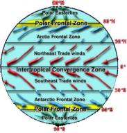
- The following 3 regions of fronts are found on the surface of the earthArctic Frontal Zone
- The Arctic front region is found in Eurasia and North America.
- Arctic fronts are formed by the meeting of continental winds and polar ocean winds. These fronts are not very active. This is because there is very little difference in the temperature of the air masses that meet here.
Polar Frontal Zone
- Polar front is formed by the meeting of polar cold air and tropical warm air. Fronts of these regions are more active in winter than in summer.
- The polar front region is more spread over the North Atlantic Ocean and North PacificOcean.
Inter-Tropical Frontal Zone
- This frontal region is spread over the Mediterranean low pressure belt.
- This frontal region is formed by the meeting of north-east and south-east trade winds at low pressure. Here, due to the convergence of trade winds, the air rises and causes sufficient rainfall
- The intratropical frontal region keeps shifting northwards in summer and southwards in winter.